Alien archeology and other mysteries: Thread 9 - The Canonn

Status
Thread Closed: Not open for further replies.
I'll be out here. Still out here. Still haven't found squat. Going on something like 6hrs now.

Ive been here for awhile...haven't seen you yet. Also i sent you a friend request.

Shouldn't the moon be at a Class Y Dwarf like at Synuefe?

The first Y Dwarf...12 only has moons with atmosphere but the second Y Dwarf has moons that are very similar except for the temp being 113k instead of 300k at Synuefe 1b
 
Interesting. You've lined up the marker blocks. And this signal has so for been found to be non repeating. So 2 thoughts come to mind -

1. it looks a bit like a genetic fingerprint. Maybe it's instructions to build a thargoid (i don't really believe this, but it would be cool)

2. maybe gather enough data it will form a picture?

Why the red line though?

It's hard to say that it is. More likely it's a words or numbers and "last block" under red line is a separator / punctuation mark.
Don't ask why red :D Paint crashed and this picture is print screen. I was just too lazy to redraw :D
 
Ive been here for awhile...haven't seen you yet. Also i sent you a friend request.

Shouldn't the moon be at a Class Y Dwarf like at Synuefe?

The first Y Dwarf...12 only has moons with atmosphere but the second Y Dwarf has moons that are very similar except for the temp being 113k instead of 300k at Synuefe 1b

Lance, are you in private group or open? I'm running over 8E at the moment after pulling all my hair out over 8C. Are you still out here?
 
Lance, are you in private group or open? I'm running over 8E at the moment after pulling all my hair out over 8C. Are you still out here?


I am in Mobius ( maybe we aren't in the same instance? ). and i am checking out 14c because except for the difference in temp the moons are very similar to the one at Synuefe 1b
 
Welp, time to revise my map!

I spent a good part of tonight at the ruins with a few other commanders, and we used multiple SRV's to do a lot of surveying. A few results from all of that work:

1. Multiple SRV's are more accurate for this kind of surveying than using ships, and easier.
2. We got numbers that very nearly matched Hamalot's surveying measurements.
3. Some of my previous measurements were indeed off, not by much, but by enough.
4. Taking exact measurements is almost impossible since the "top" of a peak or the "center" of a pad is slightly subjective, and just a wheel's length one way or another can add or subtract a meter or two from the measurement.
5. Surveyed measurements on site are much more consistent and tight than plotting lines in CAD on a JPG. If you could take an aerial pic that was guaranteed to be centered, level, and square, it might be doable, but I have no such picture, and the actual in game measurements are what I'm going to be using from now on.
6. The in game lat & long coordinates can't be used to measure distances like this. They just don't have enough unit places to get the precision needed.

With all of this in mind, I'm revising my map. It now looks like this:

gFHWSoA.jpg


Yeah, for the time being I'm putting ranges on some of the distances between systems. Let's call them "tolerances". Even with the markings and structures and guides at the ruins to mark the center of the pads, the pyramids have no such markers, so the "peaks" are more areas than points. And even with the markings on the pads there is still leeway on the actual ground with the SRV's for a meter or so difference. This isn't an exact science, and that is going to make interpreting this map (if it even IS a map!!!) more difficult.

My next job is going to be using these ranges entered into my 3D coordinate model (which works extremely accurately now) to find good candidate systems in the galaxy map which match not only the spatial coordinates but also the distances between systems measured from the ruin site, using both SOL and the ruins system as markers. After I have a list of matches compiled I'll post them here for discussion so everyone can see what my model turns up. My hunch is that it will only be a few systems total. My hope is that I find something very unique or obviously worthy of investigation. My fear is that I'll find nothing at all, lol. I'll know more tomorrow night.

For now though, I would recommend that commanders stop searching the two systems from my previous map, namely COL 132 SECTOR CN-Z B30-10 and IC 2602 SECTOR PS-J B9-10. The COL system is definitely out of range of the new measurements, but the IC system looks like it still might fall within the ranges, even if it's not a very interesting nor promising system. Still though, I'd hold off scouting their surfaces any further until I go through all of the ranges first.
 
Welp, time to revise my map!

I spent a good part of tonight at the ruins with a few other commanders, and we used multiple SRV's to do a lot of surveying. A few results from all of that work:

1. Multiple SRV's are more accurate for this kind of surveying than using ships, and easier.
2. We got numbers that very nearly matched Hamalot's surveying measurements.
3. Some of my previous measurements were indeed off, not by much, but by enough.
4. Taking exact measurements is almost impossible since the "top" of a peak or the "center" of a pad is slightly subjective, and just a wheel's length one way or another can add or subtract a meter or two from the measurement.
5. Surveyed measurements on site are much more consistent and tight than plotting lines in CAD on a JPG. If you could take an aerial pic that was guaranteed to be centered, level, and square, it might be doable, but I have no such picture, and the actual in game measurements are what I'm going to be using from now on.
6. The in game lat & long coordinates can't be used to measure distances like this. They just don't have enough unit places to get the precision needed.

With all of this in mind, I'm revising my map. It now looks like this:

http://i.imgur.com/gFHWSoA.jpg

Yeah, for the time being I'm putting ranges on some of the distances between systems. Let's call them "tolerances". Even with the markings and structures and guides at the ruins to mark the center of the pads, the pyramids have no such markers, so the "peaks" are more areas than points. And even with the markings on the pads there is still leeway on the actual ground with the SRV's for a meter or so difference. This isn't an exact science, and that is going to make interpreting this map (if it even IS a map!!!) more difficult.

My next job is going to be using these ranges entered into my 3D coordinate model (which works extremely accurately now) to find good candidate systems in the galaxy map which match not only the spatial coordinates but also the distances between systems measured from the ruin site, using both SOL and the ruins system as markers. After I have a list of matches compiled I'll post them here for discussion so everyone can see what my model turns up. My hunch is that it will only be a few systems total. My hope is that I find something very unique or obviously worthy of investigation. My fear is that I'll find nothing at all, lol. I'll know more tomorrow night.

For now though, I would recommend that commanders stop searching the two systems from my previous map, namely COL 132 SECTOR CN-Z B30-10 and IC 2602 SECTOR PS-J B9-10. The COL system is definitely out of range of the new measurements, but the IC system looks like it still might fall within the ranges, even if it's not a very interesting nor promising system. Still though, I'd hold off scouting their surfaces any further until I go through all of the ranges first.

Awesome stuff! I'll go back to the bubble and keep myself occupied until your next breakthrough. I'm getting to be quite fond of my new engineered DBX :)

Dumb question, what are your thoughts on the triangular flat structures? they are about the same size as the pyramids, only they look like dotted line versions of them (as in, this thing was here before but is no longer, or it's obscured by something else)
 
After returning from the COL sector to the ruins, and I'm not turning much up on the audio code anymore, I'll be focusing on the obelisk visual patterns for a while


I saw this earlier when looking into Spectrogram codes and had a good little chuckle "THIS is what they're trying to say!"
sadspaniel.gif
 
Last edited:
Lance Huntsman and I are checking out the binary satellites around the Y dwarf star, 14. This is a view from 14I. Notice the cluster of "stars" by comparison to the video that shows Barnard's Loop at 12' high. I think they match this: A ringed gas giant with satellites. It's Nov 11 today which is about 6 weeks from the time the video was taken showing the ruins site. Assuming it's this system (COL 137 SECTOR KY-Q D5-47), then over the course of those 6 weeks the planets could've moved to change it to how the backdrop looks now. The other point of interest is the fact that where we are, relative to Barnard's Loop, the sky is lit.

Our starting coordinates, by the way: -42, 134.

mgkC8C0.png
 
Last edited:
Lance Huntsman and I are checking out the binary satellites around the Y dwarf star, 14.


My posts are buried deep in this thread, but I said that 14 I & J were the objects I thought more appealing. I searched J for a few hours along the -48° latitude which I thought was a good match for where Barnard's might appear in the sky.

Happy surveiling CMDRs.
 
Has the mystery of 'Research Facility 5592' disappeared from the front page? I can't seem to find it.

This is on Planet HR 5991 1B with the attacked research facility base showing signs of laser fire damage and missing personnel and clues of 4 hidden signal messages, one of which refers to something that is 'not natural or human in origin' being found here before the attack/cleansing.

At the base is a revolving radar type object and also just found an optical telescope looking at a a fixed position in the sky, reflections of stars can be seen in its mirror! Is this pointing at the detected non human signal source inferred by the hidden messages????

Marked on several buildings are the letters 'PFM', which mining company or organisation is this?

Can you determine which stars the telescope is pointing at?
 
Welp, time to revise my map!

I spent a good part of tonight at the ruins with a few other commanders, and we used multiple SRV's to do a lot of surveying. A few results from all of that work:

1. Multiple SRV's are more accurate for this kind of surveying than using ships, and easier.
2. We got numbers that very nearly matched Hamalot's surveying measurements.
3. Some of my previous measurements were indeed off, not by much, but by enough.
4. Taking exact measurements is almost impossible since the "top" of a peak or the "center" of a pad is slightly subjective, and just a wheel's length one way or another can add or subtract a meter or two from the measurement.
5. Surveyed measurements on site are much more consistent and tight than plotting lines in CAD on a JPG. If you could take an aerial pic that was guaranteed to be centered, level, and square, it might be doable, but I have no such picture, and the actual in game measurements are what I'm going to be using from now on.
6. The in game lat & long coordinates can't be used to measure distances like this. They just don't have enough unit places to get the precision needed.

With all of this in mind, I'm revising my map. It now looks like this:

http://i.imgur.com/gFHWSoA.jpg

Yeah, for the time being I'm putting ranges on some of the distances between systems. Let's call them "tolerances". Even with the markings and structures and guides at the ruins to mark the center of the pads, the pyramids have no such markers, so the "peaks" are more areas than points. And even with the markings on the pads there is still leeway on the actual ground with the SRV's for a meter or so difference. This isn't an exact science, and that is going to make interpreting this map (if it even IS a map!!!) more difficult.

My next job is going to be using these ranges entered into my 3D coordinate model (which works extremely accurately now) to find good candidate systems in the galaxy map which match not only the spatial coordinates but also the distances between systems measured from the ruin site, using both SOL and the ruins system as markers. After I have a list of matches compiled I'll post them here for discussion so everyone can see what my model turns up. My hunch is that it will only be a few systems total. My hope is that I find something very unique or obviously worthy of investigation. My fear is that I'll find nothing at all, lol. I'll know more tomorrow night.

For now though, I would recommend that commanders stop searching the two systems from my previous map, namely COL 132 SECTOR CN-Z B30-10 and IC 2602 SECTOR PS-J B9-10. The COL system is definitely out of range of the new measurements, but the IC system looks like it still might fall within the ranges, even if it's not a very interesting nor promising system. Still though, I'd hold off scouting their surfaces any further until I go through all of the ranges first.

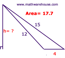
Mengy, You should be able to work out heights of things following something like this :
find-height-from-area-4.png
 
Hi, I've not visited the ruins yet - Can someone please provide a screenshot of the area I need to approach when landing please? I remember it was in the thread a few days ago. Someone circled the area of approach. Many thanks!
 
tl;dr - I think Alpha Target small pad is Gamma Velorum.

Using Mengy's original concept, and Hamelot's more detailed cartographic measurements using coordinates, I measured a bunch of points last night.
Once I had the coordinates recorded, I used the Haversine formula to calculate distances between points.

Sol pyramid to Large Pad was 375.15m. Sol to the ruins is 368.4ly
Large Pad to Small Pad was 806.49m. Ruins to Gamma Velorum is 750.54ly.
Sol Pyramid to Small Pad was 1170.17m. Sol to Gamma Velorum is 1168.8ly

Each calculated distance in metres is within 1%-2% of the distance in light years.
I'm nailing my opinion down at this point.

RuinsCoordsCalcs-Zenith.jpg
 
https://eddb.io/system/144534
Gamma Velorum
Distance to Sol: 1,116.98 ly

1099.21875 / -146.6875 / -133.59375

Gamma Velorum require an "Unknown Permit"?

T'aint that awful suspicious....

- - - - - Additional Content Posted / Auto Merge - - - - -

Lance Huntsman and I's progress tonight: On moon 14I looking for alien ruins site 2, if it exists. Current coords for this picture: -15, 117.75. The horizon matches up and looks right. If it's not on this moon but in this system, then it's on the adjacent moon a stone's throw distance away.

And we are done for the night. See you fellas tomorrow. #abouttopassout

hj23MQM.png
 
Can you determine which stars the telescope is pointing at?

Here are a couple of images of the telescope from 'Research Facility 5592' showing its interior mirror depicting the stars it is looking at. They are much clearer viewed directly than in this still image.

Here is the hidden signal message 2/4 about why we should be interested in this mystery and research station!

OqLYHxL.jpg


Whilst this level of detail is interesting as to why FD would include it, the parabolic curve makes it difficult to identify individual stars, however it should be possible to use the F1 camera to look up from the ground at the area of sky the lens is pointing to. I will try to do that later this morning and that should be good enough to determine which stars it is pointing at.

I have also included one photo of the 'PFM' lettering and symbol in case that too can be recognised by anyone. I anticipate the M will stand for Mining.

HR 5991 1B
33.4697
-2.1700

erK18Ey.jpg


qbANslE.jpg


0Ra3GF6.jpg

OK I now have used the F1 camera to go inside the telescope and have taken two photos showing the view of space it is pointed at, hopefully this will help. The first photo included the bars which are part of the telescope, the second photo I have moved slightly forward to get rid of the bars and have clear shot of the sky. Where the vertical and horizontal bars cross should be the exact centre of where the telescope is pointing at to reduce the number of stars down significantly!

I have marked in red the approximate area the telescope is centred upon, someone with 4k screen could probably get a much better image than me.

I would need the help of others here to work that out.
One red nebula is clearly visible for ID purposes, as well as lots of stars. Opening the image in new tab gives largest size photo.

xiV2Vcm.jpg

G0kpwrb.jpg

8yk04c6.png
 
Last edited:
Status
Thread Closed: Not open for further replies.
Back
Top Bottom