Alien archeology and other mysteries: Thread 9 - The Canonn

Status
Thread Closed: Not open for further replies.
I'm joining the cause, so sorry if I'm pointing something already known. And I'm near A* so I can't come and try for now.
But with CMDR Dreamstate idea, if you found a 4th site, why couldn't it be a 5th site or something at the center of the 4 ?
 
It's alright, someone's put a post up on the previous page with a photo that shows them! ;)


It's the two triangular groups outside of the perimeter directly down from the large circular platform in that image.

The old maps are all in a section on the ruins further down the front page than the current info.

Yeah that was me with the photo :) But the guy who was asking about the obelisks near beacon 2 said it weren't the one on the picture I posted. That's why I was asking what exactly he means. Because I only know of these the pre- and post-patch ruins. But anyway. No sense in discussing this if the the guy who started talking about obelisks near beacon 2 doesn't answer.
 
GUYS!

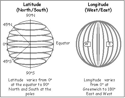
If this hasn't been thought of before, I could use some help - I heard when you want to go to the "opposite" side of the planet, you just add 180 to the co-ords - I'm not sure though, but please can someone help me with working out the co-ords for the picture I did below?

I've just tried to use notepad and a calculator to do it, but I don't think I'm doing it right:

-31.7877 -128.9711 (ruins we know of)

148.2123(+) 51.0289(+) (2nd ruins)

148.2123(+) -51.0289(-) (3rd ruins)

EDIT: Longitude won't go past 91.1xxx'ish... :/

http://i.imgur.com/nhcTWVk.jpg

You want to find 2 points on sphere that make largest equlateral triangle with ruins point. The problem is that infinite number of such points exist.
 
Longitude goes from -90 to +90, 0 being the equator. Latitude goes all around the planet so -180 to +180. For the exact opposite coordinate change + to - or vice versa on longitude and add or subtract 180 for latitude.

I think you have Latitude and Longitude the wrong way round. Longitude lines go from pole to pole (from 0 to +180 going east, 0 to -180 going west) and Latitude are the rings around the planet (north pole +90, equator 0, south pole -90).
So reverse the sign of the Latitude (first Number), and +/-180 to the Longitude (second number) for the opposite point on the surface.
 
Last edited:
from coordinates -31; -128 to parallel coordinate + -800 km in a straight line

1.The radius of planet "1b" = 1,122 km
2.(square of the hypotenuse)
 
Last edited:
Okay, revised co-ords:

58.2123(+) 51.0289(+)

58.2123(+) -77.9422(-)


FedStats_Lat_long.png


(working out below of the difficult longitude)
-128.9711
-180(-51.0289)
0 (77.9422 spare)
-77.9422

The second one was extremely hard to work out, and could be wrong... I was literally watching the numbers go up at each of the triangular bits as to know what lat/long numbers were going up and down by going forwards and backwards in my ship - so basically, both bits of the metal were both + in latitude, but only the top right one was +latitude and -longitude...

So I'm hoping both are accurate;

58.2123(+) 51.0289(+)

58.2123(+) -77.9422(-)


nhcTWVk.jpg
 
Last edited:
I think you have Latitude and Longitude the wrong way round. Longitude lines go from pole to pole (from 0 to +180 going east, 0 to -180 going west) and Latitude are the rings around the planet (north pole +90, equator 0, south pole -90).
So reverse the sign of the Latitude (first Number), and +/-180 to the Longitude (second number) for the opposite point on the surface.

Oh, you're probably right. English is not my first language.
 
This probably sounds crazy. but are the ruins changing at all? Like becoming less obvious and sinking into the ground?

I just keep thinking the ground is different when i go there. Also some images look much more obvious than others from above, or is it just light playing tricks on me?

Use these 2 images for comparison, top one is from the spreadsheet and the bottom one linked in an earlier reply which was taken in october

NQ-f-vApJ9H27SDL8wE8_0MDm-4WdUHNQKjRVTG70TP5n3lMRarntPGGw24NOG1dM-J_B-Rsfdigg9Fiw3BI_FU6xIT9Xj-anx8iE_GJnnQC0djtdIQU4NHHpiqzF5fasz6ZuBpOdQ


AJ8FuDK.png
 
Status
Thread Closed: Not open for further replies.
Back
Top Bottom