I must be missing something and ive searched both here and Google but can’t find the solution. In Horizons I can see the size of the bubble and the controlling factions are represented by their colours in that bubble. Is it possible to see the same view in Odyssey?
You are using an out of date browser. It may not display this or other websites correctly.
You should upgrade or use an alternative browser.
You should upgrade or use an alternative browser.
Bubble view on system map in Odyssey
- Thread starter He$$eeTant
- Start date
You mean powerplay view?
If that’s its name yes but rather than what I see when I click it - the system dots all turn the colour of the controlling power, I want to see the extrapolated view that was in Horizons.
To be precise all I am after is the edge of the bubble so I can leave it by 1500lys and have a small shake down exploration with my FC
To be precise all I am after is the edge of the bubble so I can leave it by 1500lys and have a small shake down exploration with my FC
Yes that’s the view. I will try that and get back to you. I had thought Id clicked it last night but perhaps id not actually selected the leader.
Thanks
Yes that’s the view. I will try that and get back to you. I had thought Id clicked it last night but perhaps id not actually selected the leader.
Thanks
Worked like a charm, thank you. I think perhaps I was too zoomed if when I first tried it.
")
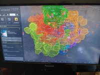
With the latest update to powerplay, it appears as we can't "see" the bubble anymore. Does anyone know of an alternative way? I'd very much like to see a general, visual representation of how the populated space is advancing through the galaxy after colonization began.
Below is a view of the galaxy map on the powerplay mode as of march 2025. Note that we can't view the bubble, and we also can't view stars on the borders of the focus point of the map, so we jus't can't view the "shape" of colonized space anymore.
It's definetly not a critical issue. But I do miss it and wonder if someone out there has found an alternative to checking on the expansion shape.
I'm also curious about this. I miss the bubble view. It really helped me visualize the space.
I have looked for this several times.
Can't even get this view in Horizons.
I got these below from Legacy PC (Shield TV) and booted up my old ED PS4 Legacy:
Had to take photo on phone and send on email as I use Sheild TV Pro for ED and obvs PS4 for PS4 - neither linked to my laptop for this forum.
Can't even get this view in Horizons.
I got these below from Legacy PC (Shield TV) and booted up my old ED PS4 Legacy:
Had to take photo on phone and send on email as I use Sheild TV Pro for ED and obvs PS4 for PS4 - neither linked to my laptop for this forum.
Attachments

On the PS4 you can take a screenshot with the screenshot button and then connect an USB stick and copy it there from the pictures gallery. You will be needing an USB stick for this. This is the easiest way to transfer pictures from the PS to PC. There might be others, but they are much more contrived.Had to take photo on phone and send on email as I use Sheild TV Pro for ED and obvs PS4 for PS4 - neither linked to my laptop for this forum.
With Powers no longer being restricted to the same sort of contiguous "blob" territories as in the original Powerplay and a lot more interleaving being possible, the old map wouldn't have worked. It only included the approximate inner half [1] of the bubble, even in the original Powerplay, because the Powers stayed away from the fringes.
With Colonisation it'd be even less accurate for showing the real borders - here's a rough map of the bubble and its growing fringes, looking from behind towards Sag A* - white dots are original systems, yellow are successful colonisations, red are ones where the first station is still in progress ... and Powerplay is still largely stuck inside the middle of the white area so you wouldn't see any of this on the old map even if it still worked.

[1] By volume, not by radius
With Colonisation it'd be even less accurate for showing the real borders - here's a rough map of the bubble and its growing fringes, looking from behind towards Sag A* - white dots are original systems, yellow are successful colonisations, red are ones where the first station is still in progress ... and Powerplay is still largely stuck inside the middle of the white area so you wouldn't see any of this on the old map even if it still worked.
[1] By volume, not by radius