You are using an out of date browser. It may not display this or other websites correctly.
You should upgrade or use an alternative browser.
You should upgrade or use an alternative browser.
Show the heatmap in the planetary map
- Thread starter Gorrister
- Start date
Also allow biology and geology to trigger the SRV radar / scanner so we know where to go once we land in a hotspot. Give biology a unique pattern and sound.
I dislike how it is implemented now. I really think they should have a function, like with the nigh vision, to reveal biology and geology that can be turned on and off after the DSS does its thing, and it can be kept on while flying around in atmosphere but turned off when it isn't needed.
I dislike how it is implemented now. I really think they should have a function, like with the nigh vision, to reveal biology and geology that can be turned on and off after the DSS does its thing, and it can be kept on while flying around in atmosphere but turned off when it isn't needed.
Lots of good suggestions, here.
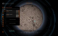
Another thing that might help, in my opinion, is to review the "heat map" and make it perhaps a semi-clear grid, something that lets one see the intensity of the signal, but at the same time allows to check the terrain underneath it.
On countless planets I have had to continually switch between combat mode and analysis mode to see what the terrain looked like, because the last thing I want to do is to end up in a mountainous area where it is impossible to land, because the heat map covers the terrain completely, and the terrain itself keeps morphing continually.
All FDev needs to do is make a toggle for the SRV radar to switch between geological and biological signals.
If they make the biologicals emit a signal just like the geologicals, then bob's your uncle!
I've encounterd stuff that's just a single tiny twig less than 0,5m high.
Try spotting that from your ship.
If they make the biologicals emit a signal just like the geologicals, then bob's your uncle!
I've encounterd stuff that's just a single tiny twig less than 0,5m high.
Try spotting that from your ship.