You are using an out of date browser. It may not display this or other websites correctly.
You should upgrade or use an alternative browser.
You should upgrade or use an alternative browser.
UAs, Barnacles and other mysteries Thread 8 - The Canonn
- Thread starter Yaffle
- Start date
- Status
- Thread Closed: Not open for further replies.
The altitude for a geostationary orbit around Merope 5c should be 30435km, not 357km.
Thank you for correcting this!
The altitude for a geostationary orbit around Merope 5c should be 30435km, not 357km.[/QUOTE
African or European ?(swallows, in anticipation)
Last edited:
Exactly what @Entomogant and i meant. The icon in the top right displays what to do... Position your ship... drop the UP... dont get in its way (stay behind it - above in orbit)... activate it by using the discovery scanner. However it will not only be the geostationary orbit - the diagram shows us where in the orbit the UP should be taken...
A geostationary orbit is always aligned with the equator (latitude 0°) and always at a fixed distance (357 km in this case), so the object in orbit can stay exactly at its position, relative to the surface... so looking at the diagram, we should be 90° (longitude) off to either the prograde or retrograde side of the orbit (right in the middle of the two markers on the lower left of the globe diagram)
[edit] Updated the graphic
http://i.imgur.com/YOWZnsO.jpg
[edit again] The term geosynchronous in our original thesis was not correct (meaning the orbit takes exactly 1 planetary day). It should read geostationary - positioned above a fixed geographic point on the planet.
Ok... I think I might know what's going on here: Our little friend wants to be introduced into Geosync orbit above Merope 2C to either study Merope 5 or Merope itself...
Following a polar geosynchronous orbit would be the perfect way to keep either in sight all day long! But it requires a third party to bring it there. US.

Makes a lot of sense.
Ps. 357km hasn't been calculated yet. I'll do it after lunch. Just pinched it from the other post.
Last edited:
No, LZ is right. Those ships were extracted with a method that cannot be used for any other model in game except ships you can fly. I know it very well cause I've done it
And printed them in 3D as well.
Basically the models were captured while playing, using the simplified rotating models on the loading screen.
Extracting 3D models from in game files, on the contrary, is fairly difficult, if not impossible (read it: 'very well encrypted')... Believe me")
Not sure they are encrypted as such, more that we dont understand the data format in the zlib streams very well yet (or at least not the mdl ones)
Found this, just wikipedia search, maybe some real data helps game fiction data
https://en.wikipedia.org/wiki/Merope_(star)
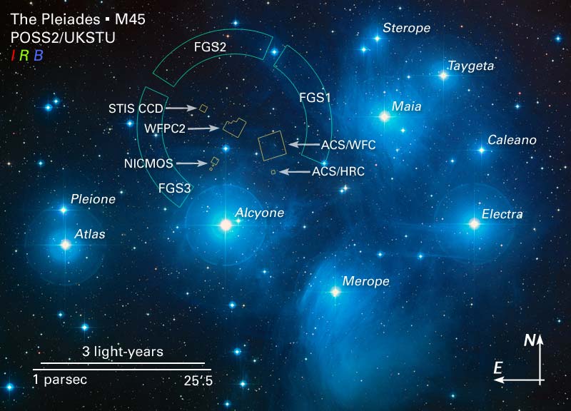
What about checking the others "daughters of Atlas"?
https://en.wikipedia.org/wiki/Merope_(star)
What about checking the others "daughters of Atlas"?
Last edited:
Ok... I think I might know what's going on here: Our little friend wants to be introduced into Geosync orbit above Merope 2C to either study Merope 5 or Merope itself...
Following a polar geosynchronous orbit would be the perfect way to keep either in sight all day long! But it requires a third party to bring it there. US.
http://i.imgur.com/fmTtkRX.jpg
Makes a lot of sense.
Erm, I'm tempted to just say nope! but instead I'll ask you to justify your theory and explain your calculations.
Call it the Brass Monkey Test.
What exactly is the 'geocentric gravitational constant'?
Why does a radius line represent that?
How have you calculated the altitude of a geosynchronous orbit?
How is a polar orbit geosynchronous? Please explain.
You've oriented 5c with 5 directly behind it. Why?
With 5 directly behind, what is the rotational orientation of 5c?
What is the significance of the 30/35 degree angles? Why isn't that angle more precise?
What is the meaning of the formula?
Why does this make 'a lot of sense'?
Lets know a bit the Pleiades:
https://en.wikipedia.org/wiki/Pleiades
This Carcossa stuff is g me out... Maybe the one coming is not Thargoids... is... THE YELLOW KING!
ALL HAIL!

https://en.wikipedia.org/wiki/Pleiades
This Carcossa stuff is g me out... Maybe the one coming is not Thargoids... is... THE YELLOW KING!
ALL HAIL!
Last edited:
Posted this before..
Illl do it agian since we are back to basic.
"just a thought"
The image is indeed the navigation ball next to the radar in every cockpit.
Select Merope 5C. Make sure its in the center of the nav ball. Now picture your self that line you see in the UP image. The diagonal one. Then pitch and yaw your ship so the "dot" (merope) moves over that fictional line till it reached the edge of the Nav ball.
What system/planet/nebula do you see now in the center of your canopy glass? That is the system/planet/nebula we need to turn inside out.
(the only thing we need to figure out now, is form what direction we need to target M5C?
I liked this idea.
I just tried it - went to Merope, lined up so that Merope 2 was directly behind the sun, so that a line was formed between Merope 2, Merope, Merope 5.
1) Centered Moreope 5C in nav compass
2) Rotated to get Moreope 5C Nav Compas dot to Position --1
3) Rotated a quarter turn (-1-) to get nav compass dot to top right hand position (-11)
4 ) ADS
....
nothing happened.
There were no obvious bodies, stars or nebula that I could see that would make sense to try and investigate. Perhaps if tried from closer to Merope 5C itself that might be something - perhaps pointing directly at the large crater on5 c? Dont have time to try myself
Good morning.
Now that we know that the UP has a 'message' lenght of 6 min, I think we need a new recording.
The UA and Barny does not have a message lenght. They never repeat.
We will porobably reset the message by disco scanning the UP. After this, we need 6 min. of sound (idealy 12min to verify repeat).
I predict that we get 3 UP wailes in those 6min, that acts as number separators. One number for each quadrant in the drawing.
Each byte is of course 3 purrs.
The two first numbers are probably radius and 1/4 sircumference, so they can be used to verify numbers.
The last two are hopefully some kind of long. and lat.
Find quite interesting the Nebra Scheibe disk (1600 BC) uses signs like the ones on the UP image
https://en.wikipedia.org/wiki/File:Nebra_Scheibe.jpg
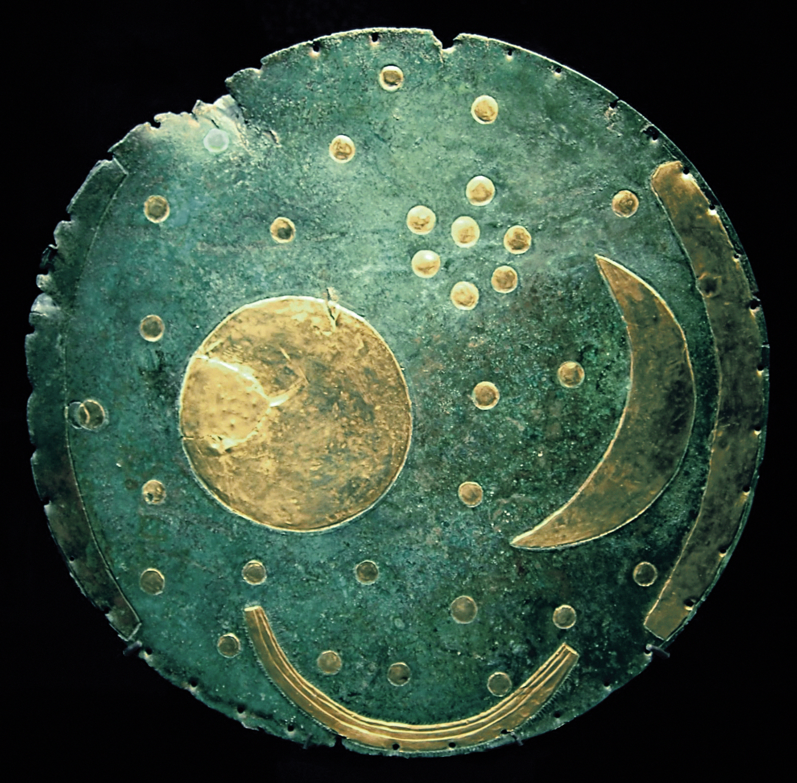
https://en.wikipedia.org/wiki/File:Nebra_Scheibe.jpg
Last edited:
Good morning.
Now that we know that the UP has a 'message' lenght of 6 min, I think we need a new recording.
We don´t know it. Please stay on the facts.
Good morning, Commanders. I'm seeing a lot of images and such being posted. Are there any new leads or are people just throwing literally everything to see what sticks?
Found this, just wikipedia search, maybe some real data helps game fiction data
https://en.wikipedia.org/wiki/Merope_(star)
https://upload.wikimedia.org/wikipedia/commons/e/e1/M45map.jpg
What about checking the others "daughters of Atlas"?
this looks like the barnacle symbol...?
Oh my friend we do know indeed! Would you please check the recent patch notes at the very bottom?
Sure I did.
Oh my friend we do know indeed! Would you please check the recent patch notes at the very bottom?
Could you link to the patch notes please? If you're referencing what I think you are then I'm not convinced that is what it's saying but I would need to read it again.
Anecdotally, noticed this flavor addition to stations affected by uas. Listen to the station announcer and look at news article. https://youtu.be/zyRngpNDnh0
- Status
- Thread Closed: Not open for further replies.