ED Astrometrics: Maps and Visualizations

On a completely separate note, I have some fairly garbled data for a couple of systems, and so these could use some fresh scans. First one is about 3k outside the bubble, and the other is near Colonia. I'll probably hit them myself at some point if no one else gets there first, but I figured I'd mention them here in case anyone is near them and wants to take a shot at it.

GMB2010 WOCS 18045

Eol Prou EB-O d6-530

Both a long way from me, but I can't find the first entry in the galaxy map, are you sure that's correct?
 
Now there's an interesting thing I pondered, a landable world with a 100% water atmosphere, it's basically a rocky world so I wonder how it got all that water, I am presuming, because of the huuuuuuuge crater I have landed next to, that a recent impact by an icy comet or something must have provided all that water. I can't recall seeing a 100% water atmosphere landable body before, they are usually much higher pressure;

TpsHrk8.jpg
 
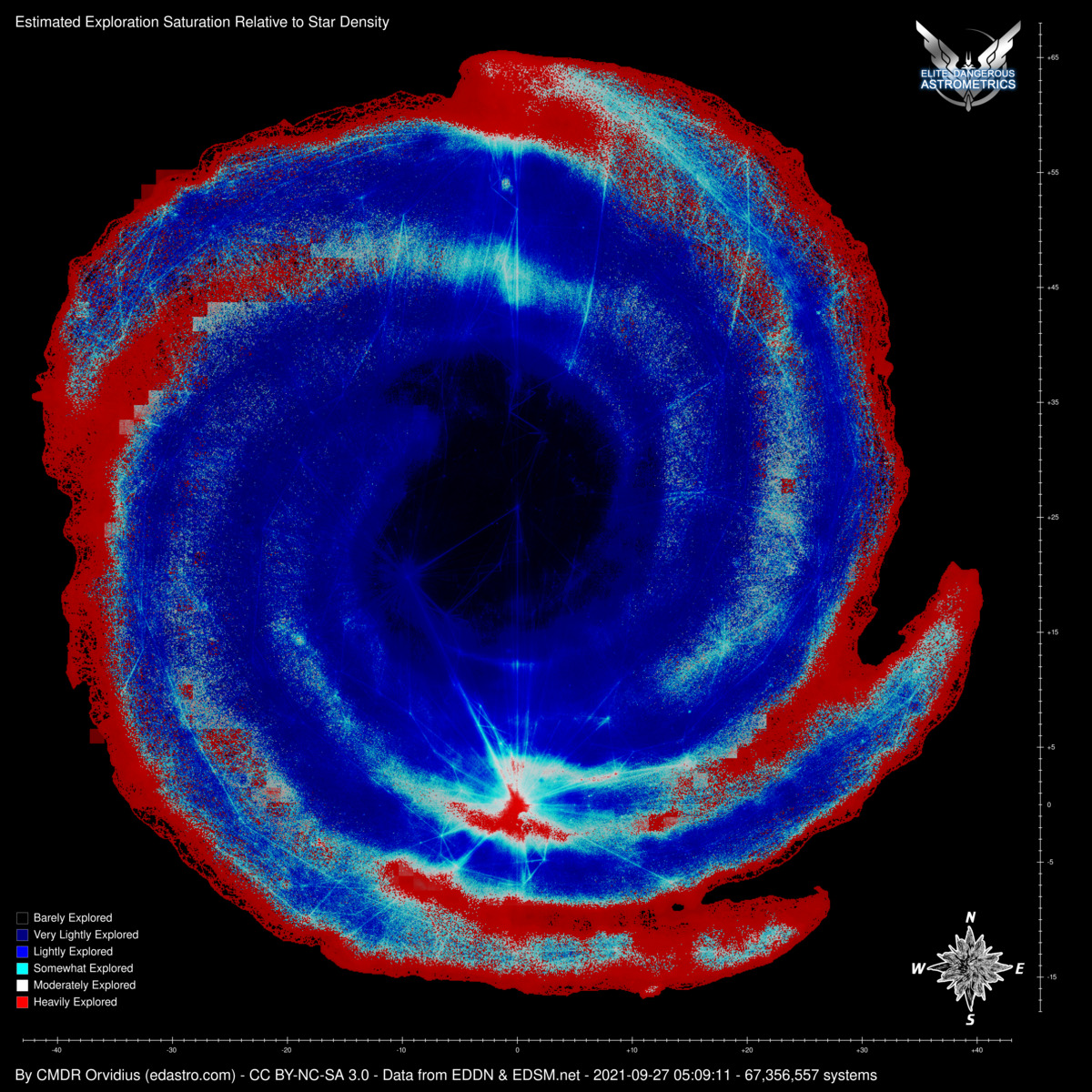
And on yet another completely different note, I just found a small long-standing bug in the exploration saturation map, that was losing fidelity (particularly affecting low-population boxels) by ignoring a couple of bits in the numbers. I'll have to re-balance the color scale now, but some more fidelity should be available to display. I'm playing with the color balance now. Test-runs take a while though, even with telling it to only process a portion of the map.
 
And on yet another completely different note, I just found a small long-standing bug in the exploration saturation map, that was losing fidelity (particularly affecting low-population boxels) by ignoring a couple of bits in the numbers. I'll have to re-balance the color scale now, but some more fidelity should be available to display. I'm playing with the color balance now. Test-runs take a while though, even with telling it to only process a portion of the map.

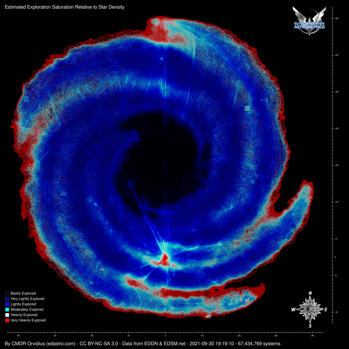
OK, colors rebalanced and bug fixed.

Here's the "before":

exploration-saturation-map-20210930.jpg


And "after":

exploration-saturation-map-20210930-new.jpg
 
Wow! The edges of the galaxy and the sparse regions between the arms have been heavily explored (red).
Is there a mistake here?

EDIT: How about trying the colors of the rainbow? For example: black, purple, blue, green, yellow, orange (red).
 
Last edited:
Oh, I hadn't noticed! This is the relative star density.

Yeah the core has a very high star density, so the number of explored stars compared to the number of existing stars is very low, so despite a lot of people being through that way, it's relatively unexplored, but out on the edges sometimes there's only a couple of routes to follow, so it is highly explored even though not a lot of people have been out there.
 
These should be the right proc-gen names:

675249856873 = Plaa Thua DA-A b42-0
5073833238785 = Plaa Thua FY-W b29-2

Since these were pretty close to the bubble, I shot over to them with my alt for some quick scans, so don't worry about these. And sure enough, they both have the same name in-game, but the proc-gen names worked to search for them. EDIT: And amusingly, EDSM still thinks it's one system, and now shows the body scans at 164% complete. :D

The one out near Colonia could still use scans, however: "Eol Prou EB-O d6-530" (18219091661115). I think this system is just three stars, but some of the numbers looked erroneous in my data.
 
Last edited:
We just had a talk about Herbig stars on the Canonn Discord. I mentioned that I have the feeling that high mass code Herbigs tend to have less orbiting bodies than low mass code Herbigs. But I have no data to back that up. Is there an easy way for you to include the number of bodies in the system in your star spreadsheets?
 
We just had a talk about Herbig stars on the Canonn Discord. I mentioned that I have the feeling that high mass code Herbigs tend to have less orbiting bodies than low mass code Herbigs. But I have no data to back that up. Is there an easy way for you to include the number of bodies in the system in your star spreadsheets?

OK, I think I have this working. I've regenerated the list.
 
Small "quality of life" update. The sector viewer search form will now take a full system name and take you to the sector. Plus it'll accept the "enter" key too. So you should be able to just paste a system name, hit enter, and view the sector.
 
With the announcement of the upcoming megaships for the Colonia Highway, I've added a marker set to the interactive map to show megaship locations. This excludes the rescue megaships (where they follow the "rescue ship" naming convention), since they're more temporary and mostly in and around the bubble. A large bulk of the remaining megaships are still in and around the bubble anyway, but there are also detention ships along the Colonia Road and elsewhere as well.
 
Oh, and this way you can also track the mobile megaships, good idea. That might come in handy in the future.
 
Back
Top Bottom