ED Astrometrics: Maps and Visualizations

Thanks for this addition! At least for me, having more POI markers makes it much easier to orient myself on the sparser parts of the map. Otherwise I found myself doing a lot of the "mouse around to get coordinates, then flip to EDSM to see what's there" dance.

Does EDSM export the POI list in a machine readable form somewhere? Might be easier going forward just to consume the full list if they do. Although at this point you're already well on your way to just reimplementing the EDSM galaxy map with a different image layer...

EDIT: And now for a bug report. Looking around, it seems like some of the new POIs you imported are conflicting with the ones you previously had. In particular, what caught my attention is that the Planetary Base marker for Polo Harbor has been replaced with a plain nebula marker for the Venetian Nebula. But maybe there's more going on here, because the Sacaqawea Space Port marker has not been replaced, and there is no mention of the Skaudai Nebula.

As far as I know, EDSM doesn't export it anywhere. That would be a cool feature though.

The Venetian Nebula marker was simply drawing over the other one (two markers in the same spot), since I didn't catch that it was the same nebula. I didn't reword the base descriptions here (Boewnst, Skaudai, etc), though I probably should. I added those markers first, since originally I was just adding deep space outposts. For now, they're at least colorized purple to indicate they're in nebulae.
 
The Venetian Nebula marker was simply drawing over the other one (two markers in the same spot), since I didn't catch that it was the same nebula. I didn't reword the base descriptions here (Boewnst, Skaudai, etc), though I probably should. I added those markers first, since originally I was just adding deep space outposts. For now, they're at least colorized purple to indicate they're in nebulae.

I've corrected these, FYI for anyone reading along. ;)
 
Last edited:
OK, I made some minor improvements on the interactive map. Using the API link from above, it is now auto-populating the nebula list. The only exceptions are the ones with bases in them, that I'm overriding. Also, it is pulling the list of permit-locked regions. And while it's using my own list of deep space outposts, it's looking for new ones to appear in the data too.

This is great since it's less work for me, and will stay up to date fairly well.
 
Last edited:
I've added a spreadsheet for "Hot Jupiters", using the official definition. That is, an orbital period under 10 days. Unfortunately there will be a lot of false positives due to binary planets, and gas giant moons of other gas giants. I'll have to look into improving the spreadsheet later, but this is a start.

I already had a spreadsheet for "Hot Gas Giants", which is different. That one looks for surface temperatures over 900 Kelvin, where they should start to faintly glow red with heat.
 
I've added a spreadsheet for "Hot Jupiters", using the official definition. That is, an orbital period under 10 days. Unfortunately there will be a lot of false positives due to binary planets, and gas giant moons of other gas giants. I'll have to look into improving the spreadsheet later, but this is a start.

I decided to narrow the above (skipping most of the false positives) by requiring it to be innermost planets only, with a name ending in '1' or '2'. This could still be thrown off if the first two planets are also a binary pair, but it should be better than before.
 
I've been making some adjustments to the valuable planets systems spreadsheet. Several people pointed out that "Delphi" was showing with 13 AWs, which are EDSM duplicates. I've just blocked this system from showing in the results. I also changed the scoring for AWs to be worth 1.75 points instead of 1 (WWs are 1 each, and ELWs are worth 2). Since the minimum score for the spreadsheet is currently "6", that means it needs 4+ AWs to show up by themselves, but they're also worth a lot in combination with the others.
 
I've added another spreadsheet onto the website. This one was suggested by Heavy Johnson, Close Landable Planets. It's a report of landable planets that are orbiting super close to their stars, within 5 ls per solar radius (or within 2 ls, whichever is larger). The idea is that these are planets that you can land on, and get a spectacular view of the star.

This one ended up being a lot more complicated than I thought. Anything looking for small orbits will tend to get flooded with binary planets and other barycentric orbits, so I needed to add a few tricks to filter those out. Some may still sneak through. But in a nutshell it looks at some of the other data captured by EDSM about planet hierarchies, where it can, and otherwise uses a limit based on arrival point if it can't figure that out. It also limits the list to the first two planets around any given star (which also meant making it understand Roman Numerals somewhat, to include Skardee I).

Right now the spreadsheet has 7,963 entries.
 
Since it came up in another thread, I've added a spreadsheet for HMCs with 5+ moons.

I also reordered the list of spreadsheets on the website to be at least somewhat alphabetical order.
 
Also coming from other thread discussions, I've made some changes to the ELW list. I've added some columns and rearranged them slightly. It now tries to determine the parent star, if it's neither the entry star nor the immediate parent body. For instance, if the ELW is orbiting a gas giant, which is orbiting a star that isn't the main star. It also tries to determine whether it's a moon or main planet, as well as whether it's a single star system or multiple. This makes it a little easier to search the list, or use filters, etc.

As a side effect, this will also appear in several other spreadsheets. A handful of them use the same script.
 
Great updates of late, many thanks!

Going through the list of data files you generate, I noticed the "Lagrange-capable stars" link. I haven't seen you post about adding that at all, is there a discussion somewhere else that that fell out of? I've had terrible luck finding NSPs on my own, so I'm certainly curious if the community has made some progress working out the necessary conditions. Perhaps someday, probably when we have more charted, you can generate an image plotting the locations of known NSPs too.

With DW2 having taken us through the core and back-and-forth across the exclusion zone (I swear every other time I log on I wind up explaining the exclusion zone to someone on squadron chat) I'm trying to wrap my head around the quirks of Stellar Forge lately. Would it be possible to break out the star-types-by-height frequency plot? The way I see it, there's at least three distinct distributions: the galactic disk generally, the core region, and the exclusion zone. It would be great to see the star type frequencies for each of those separately.
 
Isn't
Great updates of late, many thanks!

Going through the list of data files you generate, I noticed the "Lagrange-capable stars" link. I haven't seen you post about adding that at all, is there a discussion somewhere else that that fell out of? I've had terrible luck finding NSPs on my own, so I'm certainly curious if the community has made some progress working out the necessary conditions. Perhaps someday, probably when we have more charted, you can generate an image plotting the locations of known NSPs too.

With DW2 having taken us through the core and back-and-forth across the exclusion zone (I swear every other time I log on I wind up explaining the exclusion zone to someone on squadron chat) I'm trying to wrap my head around the quirks of Stellar Forge lately. Would it be possible to break out the star-types-by-height frequency plot? The way I see it, there's at least three distinct distributions: the galactic disk generally, the core region, and the exclusion zone. It would be great to see the star type frequencies for each of those separately.

Isn't that usually referred to as the suppression zone?
 
So something I thought of which at least I think could be sorta cool to see...

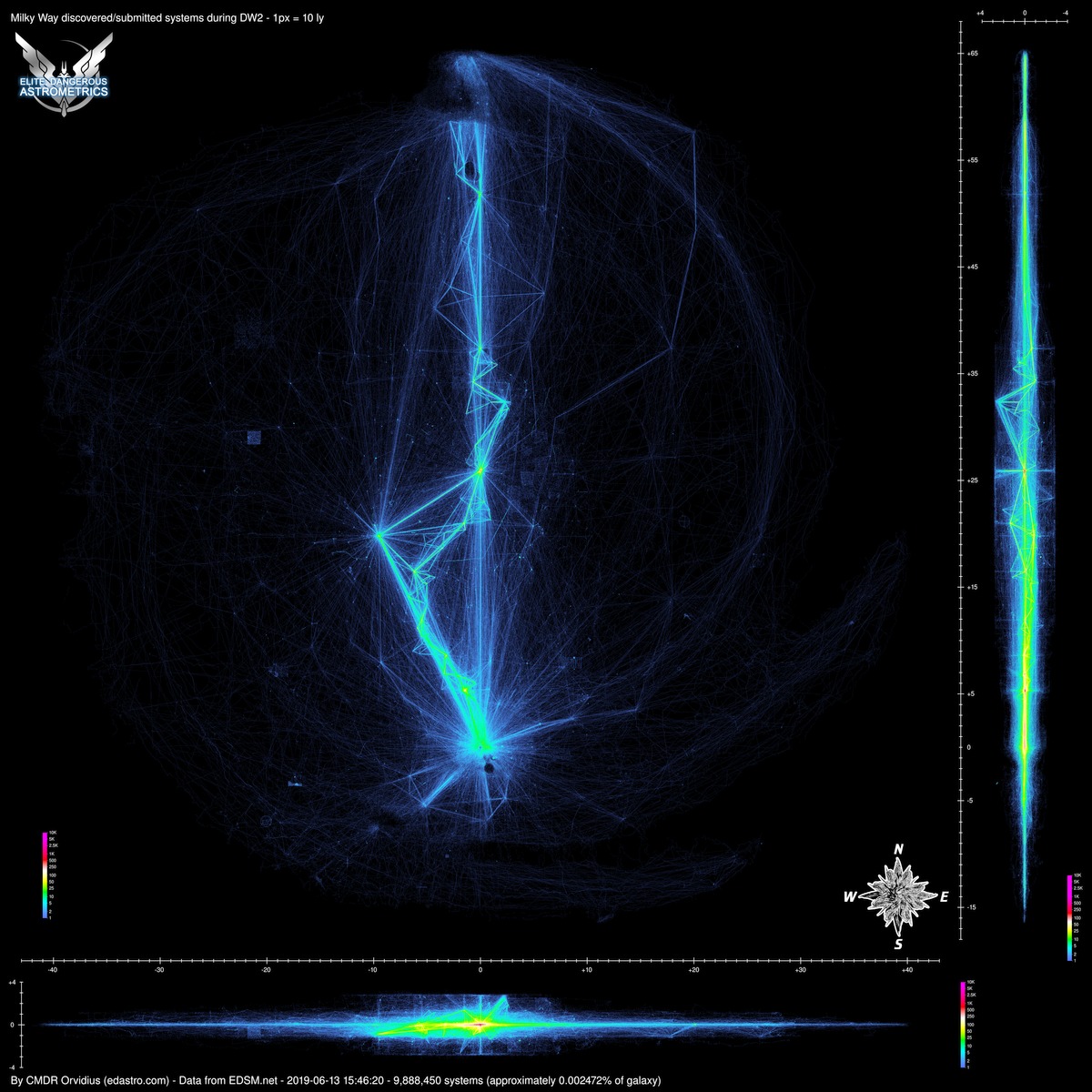
Would it be possible to do a cumulative Heat Map of DW2 between Jan. 13th and June 13th, however have the galaxy start as blank? So basically we would only see discoveries put in between those dates, with none of the previous data cluttering things up?
 
Yeah, I think the Langrange-Capable Stars came out of another thread. We were trying to think about possibilities for where there could be NSPs (notable stellar phenomena) in systems that contain only stars, and no planets. I don't recall if anyone has found any of those yet. But theoretically, Lagrange objects can exist in stable orbits as long as there is a sufficient mass ratio of the two parent objects, and so that's what this spreadsheet is reporting.

It would be interesting to see some charts split out, but the "core" versus "everywhere else" is the difficult part. In some of the maps, you can see a distinct cutoff around the core, but it's very "lumpy" and irregular. So it would have to be fudged with something simple, such as defining the "core" as being everything within 10kly of Sag-A*, for example. But both data sets would be contaminated with each other's data to some degree, because of the weird shapes in those maps. I can put some thought into it though.

Some DW2 heat maps might be cool. Hmm. I can probably make that work, but I'll have to dig through my code a bit. Adding new maps is both easy and tricky, since they all use the same code, and drawn in parallel. I think I can probably add a case where one of them is date-dependent.
 
Last edited:
From a suggestion, I've made a new spreadsheet that might help with finding scenic locations. This one reports on landable moons in inclined orbits, where the parent body has rings, and the moon orbits somewhat near to, or within the rings. With these tight constraints, it's only listing a little over 1200 moons right now. I have the thresholds set to require the moons to be landable, inclined by at least 10 degrees, and with an "orbital radius" (semi-major axis) no more than double the outer radius of the outermost ring.

As with any list that is looking for tight orbits, it can be thrown off by binary moons. I've tried to filter those out as best I can. I just hope that someday the journals (and thus EDSM) might eventually record the orbital parameters for barycenters.


Deleted member 38366

D
You know what I'd really dig?

Something like a EDMC Plugin which I could open and see :
  • fully zoomable Map of that ultra-high resolution (maybe even several Maps, i.e. one per 100LY elevation in the Galaxy and the "global one" posted)
  • with my Present Position overlay
I'd seriously love seeing where I am and correlate it with such a Map, indicating how explored the area already is and where the blank spots are.
 
Top Bottom