(Important note - there is a major change in mechanics, coming at the end of 2018, that will allow surveying surface with probes. It will make the process much simpler and hopefully more rewarding, so you may as well wait till then)
Search for volcanism - this guide is meant for pilots who never had any luck with that and need some simple answers, not for experts")
Brutal truths
1: Nobody can give you a method that will guarantee you finding something quickly. Sometimes you find them during first glide, sometimes you may spend over a day with no luck.
2: Nobody is a knowing all expert. There are other pilots with experience bigger than mine and they may have different ideas. Try them, you may like them better
3: Nobody (apart from FD) knows how many volcanic sites exist on the body, few people run surveys and I think that the number may be at least 10, but this was never proven. Even if one has 0 then the next one can have 100. Galaxy is a big big place.
4: Nobody (apart from FD) knows for sure what Major, Normal and Minor volcanism means. Maybe number of sites but maybe just the intensity of colors on the surface.
The method I describe here should help you find something in few hours.
Pick up the right body - between 400km and 500km radius. They give you fairly even long glides so you can search most effectively and you do not need months to scan it. Just in case major volcanism means more geysers, make sure you pick up such body. You can check it on EDSM ( https://www.edsm.net/en/system/bodi.../details/idB/2123725/nameB/HIP+41908+AB+1+c+a )
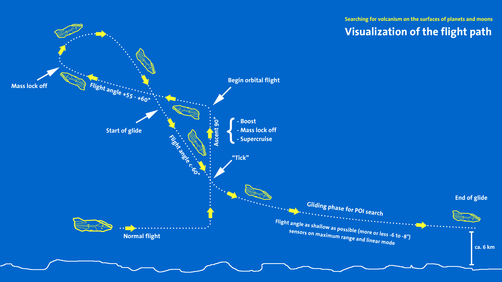
Glide along the latitude, enter the orbital flight, fly up till the mass lock goes off, aim at the ground, enter the glide as steep as possible, get to the tick altitude, glide as shallow as possible down to 6km when the glide ends. Aim the ship up and back (to compensate for the forward movement before hitting the tick again), enter orbital cruise, aim and glide, and so on until you find what you are looking for.
Start at coordinates 0° // 0° , turn your ship to 90°, aim up and start the procedure shown above. When you get back to longitude 0° then move north or south by 3° (2° will guarantee you will not miss anything, but 3° is almost as good ).
After that you should be at 3° // 0° and you can start again.
Here is a video showing Glide Method in flesh, but I would read the rest of the post first to understand what The Tick is :
[video=youtube_share;ONPxq-D28Z4]https://youtu.be/ONPxq-D28Z4[/video]
And excellent illustration of what I am trying to explain by Pilot Pirx:
Sensors:
Class of your sensors does not matter - class D shows POI from same distance (about 8km) as class A. Setup your sensors on maximum range and linear mode (https://i.imgur.com/fndWE8W.png). When flying or gliding above the ground the area covered is more or less a vertical cylinder with radius of 8km, so it does not matter how high your are as long as you are below the Tick.
Example of POI behaviour when you tilt your ship https://youtu.be/6Euvl_LNHHQ
The Tick:
When approaching the surface of the planet at some point (typically between 30km and 15km) your altimeter will jump suddenly and it may show slightly different altitude. This is the moment your sensors will start showing POI’s on the ground. On your first glide check at what altitude you are getting the Tick and use it from now on to know when you can start gliding as shallow as possible to cover greater area. The Tick altitude is different on each planet.
The POI:
Geysers and Fumaroles have one and unique POI that looks like a dot from the first moment you see it ( https://i.imgur.com/UCKYGIS.png ). Nothing else looks like that, so if you see it then for sure you have found volcanism.
Why fly along latitudes and not canyons?
Nobody really showed me convincing facts that geysers exist mostly in canyons. I found well over 100 sites, and lots of them are nowhere near any canyon.
So, if you want to spend maybe 20 minutes, then by all means check any place you like, flying along the canyons is fun, but if you want to find something, and you have 3 hours or more, than just fly straight line, this way you do not check by mistake the places you have seen already, and are not biased by the terrain you see.
Using my method I found the following sites on HIP 41908 AB 1 C A in maybe 10 to 12 hours:
Example of volcanic and other POI’ s you will see when looking for stuff, also the Tick in slowmo
[video=youtube_share;RLGpfOyz9to]https://youtu.be/RLGpfOyz9to[/video]
Some of the places I found around the Galaxy (currently working on english version ):
[video=youtube_share;DBT1XCh9nWY]https://youtu.be/DBT1XCh9nWY[/video]
Search for volcanism - this guide is meant for pilots who never had any luck with that and need some simple answers, not for experts
Brutal truths
1: Nobody can give you a method that will guarantee you finding something quickly. Sometimes you find them during first glide, sometimes you may spend over a day with no luck.
2: Nobody is a knowing all expert. There are other pilots with experience bigger than mine and they may have different ideas. Try them, you may like them better
3: Nobody (apart from FD) knows how many volcanic sites exist on the body, few people run surveys and I think that the number may be at least 10, but this was never proven. Even if one has 0 then the next one can have 100. Galaxy is a big big place.
4: Nobody (apart from FD) knows for sure what Major, Normal and Minor volcanism means. Maybe number of sites but maybe just the intensity of colors on the surface.
The method I describe here should help you find something in few hours.
Pick up the right body - between 400km and 500km radius. They give you fairly even long glides so you can search most effectively and you do not need months to scan it. Just in case major volcanism means more geysers, make sure you pick up such body. You can check it on EDSM ( https://www.edsm.net/en/system/bodi.../details/idB/2123725/nameB/HIP+41908+AB+1+c+a )
Glide along the latitude, enter the orbital flight, fly up till the mass lock goes off, aim at the ground, enter the glide as steep as possible, get to the tick altitude, glide as shallow as possible down to 6km when the glide ends. Aim the ship up and back (to compensate for the forward movement before hitting the tick again), enter orbital cruise, aim and glide, and so on until you find what you are looking for.
Start at coordinates 0° // 0° , turn your ship to 90°, aim up and start the procedure shown above. When you get back to longitude 0° then move north or south by 3° (2° will guarantee you will not miss anything, but 3° is almost as good
).After that you should be at 3° // 0° and you can start again.
Here is a video showing Glide Method in flesh, but I would read the rest of the post first to understand what The Tick is :
[video=youtube_share;ONPxq-D28Z4]https://youtu.be/ONPxq-D28Z4[/video]
And excellent illustration of what I am trying to explain by Pilot Pirx:
Sensors:
Class of your sensors does not matter - class D shows POI from same distance (about 8km) as class A. Setup your sensors on maximum range and linear mode (https://i.imgur.com/fndWE8W.png). When flying or gliding above the ground the area covered is more or less a vertical cylinder with radius of 8km, so it does not matter how high your are as long as you are below the Tick.
Example of POI behaviour when you tilt your ship https://youtu.be/6Euvl_LNHHQ
The Tick:
When approaching the surface of the planet at some point (typically between 30km and 15km) your altimeter will jump suddenly and it may show slightly different altitude. This is the moment your sensors will start showing POI’s on the ground. On your first glide check at what altitude you are getting the Tick and use it from now on to know when you can start gliding as shallow as possible to cover greater area. The Tick altitude is different on each planet.
The POI:
Geysers and Fumaroles have one and unique POI that looks like a dot from the first moment you see it ( https://i.imgur.com/UCKYGIS.png ). Nothing else looks like that, so if you see it then for sure you have found volcanism.
Why fly along latitudes and not canyons?
Nobody really showed me convincing facts that geysers exist mostly in canyons. I found well over 100 sites, and lots of them are nowhere near any canyon.
So, if you want to spend maybe 20 minutes, then by all means check any place you like, flying along the canyons is fun, but if you want to find something, and you have 3 hours or more, than just fly straight line, this way you do not check by mistake the places you have seen already, and are not biased by the terrain you see.
Using my method I found the following sites on HIP 41908 AB 1 C A in maybe 10 to 12 hours:
pumpkins:
HIP 41908 AB 1 C A 5.8876 -107.4878
HIP 41908 AB 1 C A -16.6021 -78.8721
HIP 41908 AB 1 C A -19.4121 23.8399
brain trees:
HIP 41908 AB 1 C A 2.2886 1.8509
HIP 41908 AB 1 C A -3.0142 52.7901
bark mounds:
HIP 41908 AB 1 C A -1.1483 26.5604
HIP 41908 AB 1 C A 10.5415 123.8627
HIP 41908 AB 1 C A 9.7212 -30.1957
geysers:
HIP 41908 AB 1 C A 3.4231 -148.7106
HIP 41908 AB 1 C A 11.2331 -108.0491
HIP 41908 AB 1 C A 13.6156 -131.5787
two permanent outcrops at:
-1 // 31 and 0 // -16
Example of volcanic and other POI’ s you will see when looking for stuff, also the Tick in slowmo
[video=youtube_share;RLGpfOyz9to]https://youtu.be/RLGpfOyz9to[/video]
Some of the places I found around the Galaxy (currently working on english version
):[video=youtube_share;DBT1XCh9nWY]https://youtu.be/DBT1XCh9nWY[/video]
Last edited:
