The lines are thin, but they need to be that thin to precisely highlight your route. If I enlarge the image it's fine (and I love the level of detail).
Pomeche claims yet another SRV. Or two, as it got mine shortly after. It should have warnings as people arrive!
@sgurr The thing that really struck me about the ending in retrospect was that you'd been able to climb all the mountains that I'd failed (and I avoided a couple more due to lack of landing sites). I just hope that the last jump hadn't lulled you into a false sense of security as I had made it first time (so it can't be too bad, right? ) But.. Too late now. Pomeche has spoken.
I'll put some footage together when I get a chance too.
Thanks Crank
No false security, I could see it was tricky, especially with the momentum from the drop. Thought I'd picked an ok landing but got an awkward bounce, then another when I thought I'd pulled it back.
Given how far I've travelled I'm surprised I haven't been properly off something before now.
Well the safety systems worked, at least for keep me in one piece.
Same definitely couldn't be said of the SRV, that spread itself liberally across the canyon floor. After thrashing my way out of the impact cocoon I recalled the ship, and thankfully my picked 'landing' spot while heading down was just that, with the ship autpilot easily setting itself down.
Looking west:
Looking back east:
At first glance I wasn't too concerned about getting out of the canyon.
However, I have a general moto when out and about exploring, to leave no trace, so the first task was cleaning up the mess.
Took me the rest of the Pomeche day and most of the night to find everything, and even then I only found one of the perpetual engines that make for the wheels, tricky things to track down those.
I'd put money on one of them having completed the circumnavigation by now, Alec has an excellent video demonstrating why:
I spent rest of the night most of the next day recovering from the beating my body had taken with the landing (extreme braking really) and parts recovery with the ship's med systems working overtime.
In my naivety I'd hoped to just use the one srv going round, but the murder rocks now sat ever so innocently around my ship had put paid to that.
So task 2 was prepping the spare, and that took a while given that I'd be using it as a cupboard.
Then spraying it down with the 'Premium Hull Preparation' formula TM, cause that worked well for the previous one right?
It's some kind voodoo I'm sure but I'll try anything that'll help.
Then onwards, up there maybe? :
That's where I came from, and it would be nice to carry on the route so I give it a go ...
and after scratching and grovelling my way up roughly half way I find myself struggling to maintain position on the slope much less make any progress and when looking across to the other side of the canyon it's getting more appealing by the second...:
... as that looks vary managable by comparison
(note: the angle of the shot is about 70 degrees down)
Down and back up I go and thankfully it's a steady climb and I can eventually take stock and plan my next move:
with the line on the right where I fell down.
As best I can tell from here the 2 arrows on the left are pointing at one ridge running from behind/above me with a steep drop and climb in between the arrows. I could probably head straight up onto the ridge but I do like going end to end on a ridge ao backtrack East for a way to find the start:
A little flyving later and I'm on the ridge, enjoying the panorama and recalling the ship for a break:
I had intended to carry but a 'short nap' uses up the rest of the daylight and so I settle in to wait for the next dawn.
o7 cmdrs
I was absolutely gutted when I exploded, turned the air blue when it happened.
The text chat actually, which given I was winged with Crank was already the right colour.
I hadn't committed to doing it in a single SRV but the longer things went on the more I assumed I would be finishing in the same one I started, but it wasn't to be.
This is about having some fun adventures while seeing if I can SRV this particular world. While I'm committed to covering every metre by SRV I realised that starting again because of some 'murder rocks', and not in-flight repairing when I should have, would not be fun.
Glad to hear you've walked away from that crash unscathed. With all vehicle parts gathered, even if your spare SRV will get similiar unfortunate treatment, you'll have resources to build another one, which, technically will be the first one. Hopefully it will not be necessary.
I'm well rested and keen. Looking around I chose a good spot to park...:
and a good direction cause south looks like a nightmare!
There's this circumnavigation thing I've been putting off for a good few days now while playing around on ridges, it's time to move.
From the orbital map I'm on a ridge system that 'should' take me clear of this area and onto the plains out west.
Deploying the SRV I pop over the summit just ahead...:
...and my hopes were right. Even though there are dips the ridge I'm on continues as far as I can see. Crossing fingers I hope the terrain on the drops is managable, and that I've managed to sate my lemming tendencies for a little while.
The comms chirp and I have a brief chat with Cmdr Osashes who's practising for the last SMC event this weekend, and Alec's also online. I'm about to o7 when I notice that he's in Evelyn's Light.
I'm sure many know but there's a memorial out there to a brave young lady. Alec linked the relevant thread and I'll do it again here: memorial-for-my-little-commander
I pause and offer some thoughts, and wait until I notice Alec's well clear of the system. I also notice that the ly's are dropping rapidly and confirming that he's buckballing back to the bubble I'm struck by the thought that he might be home before I'm even halfway and we started about the same time.
Eh no, and then nearly rip the throttle from the mountings as I jam it forward, then promptly yank it back before I soar over an edge.
Need to make like the tortoise. Sort of.
The two dips in the photo above have some gnarly terrain and require care to negotiate. They are thankfully wide enough that dropping off isn't an issue, but I really need to stop face planting every rock I see. The landing autopilot isn't sentient, but I can tell even it's getting testy at the number of recalls I need here.
Finally...:
... I can look back and can see just lumpy the terrain I've been crossing is.
I mean, obviously the hull damage was telling but when you're in the middle of it all it's never clear if it's the terrain or really poor route choice.
Definitely the former today.
It's here I'm checking longitude when I realise that my fall on Day 17 was roughly equal to the furthest I'd been, and I was now ticking down some new degrees. Awesome!
The ridge eases back for a while but it wasn't finished with me, and I got bounced so hard today I've trouble remembering what's what but I 'think' this was looking back at the last serious crossing:
and not long after I finally got the view I was looking for:
The worst was hopefully over, and I was relishing rocky goodness from here on out.
Finger's crossed and for a while anyway.
For the first time in many days I can actually relax and unwind the SRV's legs, skipping along at grin inducing speeds for long stretches. It's brilliant, and I'm enjoying the views as I go:
It's while I'm parked up later that I realise most of the icy ridges are receding:
And sure enough, when checking my orbital shots it looks like I'm past the most densely packed ridge terrain. Still on one though and so if you enjoy srv journeying and sightseeing throw on 18 minutes of appropriate music and sit back (still rendering as I post):
Until finally I park up for the night with Pomeche 2 and the nebula rising above me:
Looking over the logs I've covered nearly 25 degrees today and am now at -9, 141, less than 20 degrees until I'm halfway. I'm psyched for that.
The world shot. I'm not actually 100% where I am, but fairly sure I've popped off the left edge of the shot, and days 17 and 18 markers are very close together:
... and head off following the ridge onto that next rise, at which point it vanishes and I no longer have a ridge to follow.
That's actually helpful though, as I wasn't sure where I was yesterday, and now an educated guess leaves me roughly here:
Besides getting off and onto Alec's ridge the only area I had scouted before starting was this halfway area, just to check it wasn't hidden deep in an impossible canyon (cause Pomeche could do that).
Actually, to be honest that was the second area I'd scouted.
The ridge starts at 13, -60, so my first attempt took me to -13, 60 cause I just needed to reverse the numbers right?
Felt like a numpty when I realised that's 240 or 120 degrees from the start, not 180, and this only a couple of days before starting out.
What I was really looking for -13, 120, and when I flew over the area in the dark it looked fine and I didn't need to go down for a closer look, just a snap of the surface map and it's arrow.
Now I'd love to show some pics here of the journey but turns out my dashcam malfunctioned and except for opening/closing remote camera shots I have nothing useable for today.
My aim was to make halfway, and I initially I followed the icy canyon on my left, and that when this started to bend round and head north to cross.
The terrain wasn't ideal flyving material. It's hard to describe without photos but long smooth ups and downs means a lack of bounce points for flyving.
Instead I built up speed where I could and soft landed where I needed for some actual driving.
It's actually a welcome change as the scenery isn't that inspiring, lots of rolling brown with almost nothing to break the monotony, and trying to keep control scooting down and up massive and perfectly smooth surfaced crater depressions while actually on wheels made for a cool change of pace.
Navigating is also tricky without obvious features and I was relying on the icy canyon on my left, but as it turned north and it was time to cross I realised that my target area was wrong, as from my coordinates I was several degrees north of where I needed to be.
A little head scratching later and I finally realised that the system map location arrow doesn't directly point to where I am, rather it floats above the real location which is the tiniest blue dot below. In my defense I haven't been using it so far as it's not detailed enough for finding ridge ends.
So instead I turn south and slowly zero in on the coords, and arrive at a random bit of slope:
I'm absolutely psyched about this, and there may have been a cheer as the coordinates ticked to zeros.
I looked around and of all the places that Pomeche could have chosen for my halfway spot this was, well, brown. And rolling.
With views of more brown, and rolling.
Pomeche 2 and the nebula were up:
And the ship landed close by:
Where to go now?
Well the epic mountain range is the big target, a loooong way to the north and west, but how to get there is an open question. I want to cross as little icy terrain as possible, so my 2 current thoughts are either due west for a bit to some isolated mountaings then north west, or north west now.
If folk have suggestions feel free:
Apologies for the wordy post, had some fun things happen but not worth describing without video. You didn't miss anything with the terrain.
I'm well rested and keen. Looking around I chose a good spot to park...: View attachment 206706
and a good direction cause south looks like a nightmare!
There's this circumnavigation thing I've been putting off for a good few days now while playing around on ridges, it's time to move.
From the orbital map I'm on a ridge system that 'should' take me clear of this area and onto the plains out west.
Deploying the SRV I pop over the summit just ahead...: View attachment 206701
...and my hopes were right. Even though there are dips the ridge I'm on continues as far as I can see. Crossing fingers I hope the terrain on the drops is managable, and that I've managed to sate my lemming tendencies for a little while.
The comms chirp and I have a brief chat with Cmdr Osashes who's practising for the last SMC event this weekend, and Alec's also online. I'm about to o7 when I notice that he's in Evelyn's Light.
I'm sure many know but there's a memorial out there to a brave young lady. Alec linked the relevant thread and I'll do it again here: memorial-for-my-little-commander
I pause and offer some thoughts, and wait until I notice Alec's well clear of the system. I also notice that the ly's are dropping rapidly and confirming that he's buckballing back to the bubble I'm struck by the thought that he might be home before I'm even halfway and we started about the same time.
Eh no, and then nearly rip the throttle from the mountings as I jam it forward, then promptly yank it back before I soar over an edge.
Need to make like the tortoise. Sort of.
The two dips in the photo above have some gnarly terrain and require care to negotiate. They are thankfully wide enough that dropping off isn't an issue, but I really need to stop face planting every rock I see. The landing autopilot isn't sentient, but I can tell even it's getting testy at the number of recalls I need here.
Finally...: View attachment 206707
... I can look back and can see just lumpy the terrain I've been crossing is.
I mean, obviously the hull damage was telling but when you're in the middle of it all it's never clear if it's the terrain or really poor route choice.
Definitely the former today.
It's here I'm checking longitude when I realise that my fall on Day 17 was roughly equal to the furthest I'd been, and I was now ticking down some new degrees. Awesome!
The ridge eases back for a while but it wasn't finished with me, and I got bounced so hard today I've trouble remembering what's what but I 'think' this was looking back at the last serious crossing: View attachment 206709
The worst was hopefully over, and I was relishing rocky goodness from here on out.
Finger's crossed and for a while anyway.
For the first time in many days I can actually relax and unwind the SRV's legs, skipping along at grin inducing speeds for long stretches. It's brilliant, and I'm enjoying the views as I go: View attachment 206715
It's while I'm parked up later that I realise most of the icy ridges are receding: View attachment 206713
And sure enough, when checking my orbital shots it looks like I'm past the most densely packed ridge terrain. Still on one though and so if you enjoy srv journeying and sightseeing throw on 18 minutes of appropriate music and sit back (still rendering as I post):
Until finally I park up for the night with Pomeche 2 and the nebula rising above me: View attachment 206717
Looking over the logs I've covered nearly 25 degrees today and am now at -9, 141, less than 20 degrees until I'm halfway. I'm psyched for that.
The world shot. I'm not actually 100% where I am, but fairly sure I've popped off the left edge of the shot, and days 17 and 18 markers are very close together: View attachment 206719
New map next time!
Absolutely wonderful! (and thanks for giving me some time at Evelyn's Light ... very thoughtful of you).
Also ... I'm pleased to see I'm not the only one who, no matter how many times I do it, still forgets to pre-select repair synthesis before I head off.
I drop out the ship ...: View attachment 206828
... and head off following the ridge onto that next rise, at which point it vanishes and I no longer have a ridge to follow.
That's actually helpful though, as I wasn't sure where I was yesterday, and now an educated guess leaves me roughly here: View attachment 206830
Besides getting off and onto Alec's ridge the only area I had scouted before starting was this halfway area, just to check it wasn't hidden deep in an impossible canyon (cause Pomeche could do that).
Actually, to be honest that was the second area I'd scouted.
The ridge starts at 13, -60, so my first attempt took me to -13, 60 cause I just needed to reverse the numbers right?
Felt like a numpty when I realised that's 240 or 120 degrees from the start, not 180, and this only a couple of days before starting out.
What I was really looking for -13, 120, and when I flew over the area in the dark it looked fine and I didn't need to go down for a closer look, just a snap of the surface map and it's arrow.
Now I'd love to show some pics here of the journey but turns out my dashcam malfunctioned and except for opening/closing remote camera shots I have nothing useable for today.
My aim was to make halfway, and I initially I followed the icy canyon on my left, and that when this started to bend round and head north to cross.
The terrain wasn't ideal flyving material. It's hard to describe without photos but long smooth ups and downs means a lack of bounce points for flyving.
Instead I built up speed where I could and soft landed where I needed for some actual driving.
It's actually a welcome change as the scenery isn't that inspiring, lots of rolling brown with almost nothing to break the monotony, and trying to keep control scooting down and up massive and perfectly smooth surfaced crater depressions while actually on wheels made for a cool change of pace.
Navigating is also tricky without obvious features and I was relying on the icy canyon on my left, but as it turned north and it was time to cross I realised that my target area was wrong, as from my coordinates I was several degrees north of where I needed to be.
A little head scratching later and I finally realised that the system map location arrow doesn't directly point to where I am, rather it floats above the real location which is the tiniest blue dot below. In my defense I haven't been using it so far as it's not detailed enough for finding ridge ends.
So instead I turn south and slowly zero in on the coords, and arrive at a random bit of slope: View attachment 206833
I'm absolutely psyched about this, and there may have been a cheer as the coordinates ticked to zeros.
I looked around and of all the places that Pomeche could have chosen for my halfway spot this was, well, brown. And rolling.
With views of more brown, and rolling.
Where to go now?
Well the epic mountain range is the big target, a loooong way to the north and west, but how to get there is an open question. I want to cross as little icy terrain as possible, so my 2 current thoughts are either due west for a bit to some isolated mountaings then north west, or north west now.
That 2nd globe picture looks worryingly like being one side of a massive raging complex of rapids and waterfalls and realising you need to be on the other side! Am I right in thinking blue = bad roughly?
Also ... I'm pleased to see I'm not the only one who, no matter how many times I do it, still forgets to pre-select repair synthesis before I head off.
That 2nd globe picture looks worryingly like being one side of a massive raging complex of rapids and waterfalls and realising you need to be on the other side! Am I right in thinking blue = bad roughly?
Nursery Rhymes: The bear went over the mountain. An animated version of the children's nursery rhyme 'The bear went over the mountain' with lyrics.
www.bbc.co.uk
On with the show then, it's been a while:
Pomeche 2 hung in the sky as I set off. After musing on choices I'd decided that west was the best choice, the most rockiness for flyving and least icy rapids for difficulties when I then headed north.
My previous mistake about where my halfway point was actually meant I had a good bearing on where I needed to aim:
So I aim mainly west with a slight angle south to take me past the worst of the icy terrain in my path. I kinda want to make good ground while I can so don't think much about distractions along the way.
Almost immediately though:
I spy an escape pod in need of recovery, so scoot around and pick the unfortunate up. They're a recent crash, so hadn't gone fully under, and are so sweetly grateful that it really warms the heart and makes me feel like a hero!
Except, I've gotten just far enough away from the ship for it to have dismissed and am impatient to be off, so I advise them to strap in and that we'll be back at the ship in no time.
Seconds later as I'm hitting the first of my bounces and accelerating they're not so pleased, distinctly unhappy actually.
I offer to put them back or stick with me while I get some kms under the wheels, and I take the silence as an agreement to crack on.
The silence is temporary though, and as a build up speed there's a fair amount of, well, shall we say enthusiastic exclamations? I'm concentrating so can't pay them too much attention, although there's mention of somethingsomething buckyballer, but when I hear the wretching I have to turn the comms volume down.
I mean, I thought those pods could deal with almost anything but apparently srv flyving is not one of them.
Poor sod.
Anyway, it's more brown and rolling terrain, and while the flyving is definitely fun and unstressful there's not much of interest to look at. Taking the occassional high bounce I keep an eye on the horizon for the icy terrain I'm steering around and make good progress, eventually stopping for a quick repair and break with the ship. I also unload the now silent escape pod for good measure, I guess they eventually asked the pod to knock them out
I set off again, challenging myself to soft land from flyving into the highest speed I can on wheels when I pop out of a shallow crater to this ...:
... little invitation on the horizon.
And you know, when it's such a polite, gentle invitation it would just be rude to refuse so less than a minute later my course is dead centre for the peak.
I hadn't really been planning to look at the mountains, but now they're there I just can't say no.
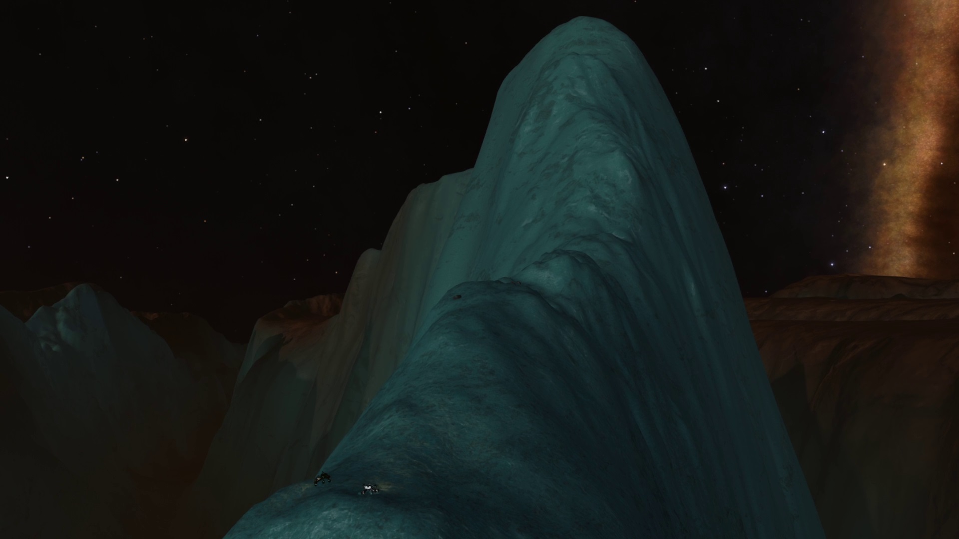
7 or 8 minutes later I pop over a rise and the moutain reveals itself.
I am not disappointed:
The immediate icy canyon ahead is steady but shortly after something altogether narrower and steeper comes out of nowhere, and well see for yourself:
I build up as much speed as I can on the rest of the approach and begin the climb which takes about 14 minutes. The video is running at 2x speed and there's a full panorama from the summit:
What I had no idea about on the approach, or until very late on the climb itself was what I would see on the other side of the mountain, and it wasn't just the other side of the mountain but something much, much grander:
When I picked my jaw up I had a look the other way at Pomeche 2:
and then a look towards where I'm heading and couldn't believe what was sitting right on my path:
So that needs to be climbed!
Tomorrow though.
Recalling the ship it settles on a flat area just below the summit and I settle in for a break, checking in with the latest escape pod 'victim' who's still breathing if not entirely happy about the situation. Apparently I've gotten quite the reputation among those I've 'rescued' now, and they'd really like to go home.
Sorry, gonna be a while yet!
Today's map, and about 19 degrees covered plus 6 south:
I had no idea looking at this or my route options map just how dramatic these mountains would be up close. I love stumbling on stuff like this.
Day 22 - part 1: Maybe 'Plains Drifter' was the wrong name?
I deploy the srv and then sit for a looong time just taking it all in:
I've covered some incredible ground and views but I think this might be my favourite landscape so far.
It turns out that Cmdr @cratercamper was sitting in the middle of those peaks around the same time I was, just a shame we weren't active at the same time. I love that this world's geography means there's always someone exploring or hooning about on its surface, even if we don't come across each other.
I've covered most of this journey by flyving rather than driving, and while cratercamper is a fellow circumnavigator he's the hardcore version that goes round mostly driving. I suspect I miss fun stuff when I get I've got mountains beckoning on the horizon and I open the throttle.
Eventually, reluctantly, I figure it's time to move.
Of course, there's only one acceptable way off this mammoth hunk of rock ... :
... and it's straight down.
There are some enormous base jumps in the galaxy, and this isn't one of them but it's still a hoot when you take your run up and launch into freefall:
I think it was 14 minutes up, and just over a minute down, just love that!
My landings were less than stellar and for their sake I was glad there wasn't some poor escape pod/sod in the back, I was having a hard enough time dealing with it and I could see what was coming.
Actually, maybe that was the problem.
Once I straightened myself out it was a direct line to the very peaky peak in the right of the opening shot and occassionally get high enough bounces that I can take a proper look around both back to where I jumped from ... :
... and ahead t the next peak which after losing sight after my initial base jump has started looming into view again:
Figure that out flat earthers.
As I get closer of course I have a good look around to try and pick the best line up ...
Nah, I'm not that sensible. I build speed and go straight for it figuring I can only fall off, the lack of narrow icy canyons to get trapped in is making me relaxed, or cocky.
Inevitably in hindsight I do think I went up the steepest part. Ah well.
After my initial momentum had been spent I resorted to steep zigzaging, boost udging and general grovelling as I scratched my way up the side of the mountain. On the odd occasion I stopped to take it in I figured the horizon shouldn't look like this:
Nice views though and another treat when I got to the summit:
Another pause to take it all in, and also to check the maps and make sure I am where I think I am.
Then it's time for base jump number 2 of the day with the distant mountain my next marker and aim:
aaannd another gratuitous selfie as I plunge down:
Pictures like this lose their sense of scale I think, it kinda looks like I've just boosted a little off the jaggy peak below me.
In reality I spent 2 minutes in freefall this time, and the landing went mostly ok and I carried most of the speed onto the plain, then gradually, and intentionally, losing it to minimise impact damage on the srv.
With the initial momentum I make good ground and it's not long before it's time to pull over for a rest.
Recalling the ship I have a new mountain that while smaller than those I've been on today is still something enticing to enjoy later:
I asked a fellow Cmdr (my alt) if they would be kind enough to get a lower level orbital shot for me, which I've then touched up with the last 2 days journeys:
Even without my beloved ridges I think the landscape is really quite stunning.
That really is quite stunning...
How much longer do you think your 'trip' is going to take? Both main accounts are in the bubble currently, one will do some pew-pew in the CG, this one could be sorely tempted to try to ride along with you for a little while
That really is quite stunning...
How much longer do you think your 'trip' is going to take? Both main accounts are in the bubble currently, one will do some pew-pew in the CG, this one could be sorely tempted to try to ride along with you for a little while
I've attempted a couple of Pomeche summits, starting from the valleys and climbing all the way. All I've achieved so far is some spectacular falls and landings at the highest speeds I've ever made - and survived (mostly).
But your current location takes the prize for best scenery.
The terrain was comfortable and it wasn't long before:
I was making the final approaches and realising that this would be an ok climb, generally easy angled and I decided to aim for the left flank and follow that to the summit.
I'm part way up when I spot something:
Is that a T10 on the mountain's shoulder?
I've not come across anything nearly that big since starting and I'm intrigued, but I'm also still carrying momentum form the plains approach so making a mental note I concentrate on the summit where it's easy to recall the ship.
My next target peak is poking above the horizon below and left of the nebula:
I also take a moment to look back at the incredible set of peaks I've left behind, still towering above the plains and horizon despite being close to 200kms away with my last summit the pointy one on the left:
Now, I had planned to stop here but I can't resist going back down to have a chat with the T10, cause it's a T10 and I don't think I've ever seen one up close, and also because you don't use a behemoth like that for just any old job and my nose is twitching.
Back down I go:
For a closer look and a hello. Jan Henrik's their name, and comms silence seems to be their game:
Massive isn't it?
The srv could probably fit in the cockpit, and I'm tempted at least to just get something other than stoney silence from them, but I need to see what they're here for.
Sure enough there're canister signals close by so I slink off for a look at the juicy treasure they're guarding.
Except of course it's nothing but barely precious metals industrial parts.
Well Jan Henrik, you must have had a real purple patch to get that ship, but you also must've fallen a looong way if this is what's makes for a good job these days. Even I can't be bothered to pick it up.
I can't help feeling a little disappointed so decide to get off the hill and set up camp on the plains below to the west:
Before settling down for a break I have a quick look through the recent days records:
and my route:
That's all for now, the following day I got a visitor.
The day opens without fanfare, sitting at base of yesterday's peak. The sun is high and its light drowns out the landscape's colours:
The main aim yet another peak I spotted on the horizon yesterday, and one that I know from a previous mistake is a marker to look forward to.
I'm expecting a steady and enjoyable run, just letting the degress tick down but I'm barely out the ship when the comms chirp and I realise that not only is Cmdr Osashes on world hooning around in his newly engineered Eagle, but is wondering if I'd mind him imposing to buzz around in his srv for a bit.
Heck yeah.
When I first realised he was on Pomeche I'd half expected him to be on Alec's Pomeche Ridge run. You see Osashes, on his very first ever attempt on the ridge, had snatched 2nd place on the Black run, which is just astonishing given that some of those behind him have done a 3 figure number of attempts for their places. And this from someone who's only flyved for less than a year. He's also the recent winner of the Scarab Mastery Championship, and ridiculously modest about how skilled he is. (Hope that's not too much Osashes o7)
It's not long before he's on the surface.
I wish I'd taken the time to get a proper shot of his ship, it's a thorough bred racer that one, and I'm gonna need to give my own Eagle some tlc when I get back to it after I'm done here:
There are some comments about the terrain not being very Pomeche like, ie. not massive ridges and srv swallowing canyons, but it's still a grin inducing morning taking the lead in turns as we faceplant a rock (me) or graciously wait (Osashes) cause someone is too busy taking vanity shots (me again):
and it's not long before my next mountiain pops up above the horizon while it's still ~200kms away:
Shortly after I notice the first signs of icy terrain. I know from orbital shots that there's a LOT of this ahead. I don't really how serious it will be but for now I'm just conscious that it's getting closer.
As is the mountain:
I don't make a habit out of going sideways, or try not to anyway, and Osashes definitely doesn't normally go backwards (that's Alec's domain):
and then we're at the mountain base ...:
... and it's time to put the foot down, build speed and momentum our way to the summit.
And what a summit, not for the mountain itself but for what appears around us as we get there looking back east with my last peak just nudging above the horizon right of the nebula:
and west with the next marker on the journey:
"Beautiful"
Yeah, it really is.
Osashes has business elsewhere and needs to leave, and I was planning to stop here for a break anyway.
I linger for a while though.
When I made my mistake with halfway co-ordinates this was where I'd mistakenly come, which means I've now covered 240 degrees. I'm 2/3rds of the way round and that's suddenly feeling like a really big deal.
My plan from here is through those mountains and then northwest to a tourist beacon marking the Epic Mountain Range, and the mountains themselves of course.
It's been an early morning dash for me, and I've not had breakfast yet so I recall the ship for a break.
Maybe a nap too.
I mark up the lower orbital map and it's done.
I smile every time I look at this, it's been a real highlight of the journey:

 ) But.. Too late now. Pomeche has spoken.