You are using an out of date browser. It may not display this or other websites correctly.
You should upgrade or use an alternative browser.
You should upgrade or use an alternative browser.
Alien archeology and other mysteries: Thread 9 - The Canonn
- Thread starter Ian Phillips
- Start date
- Status
- Thread Closed: Not open for further replies.
Guys... Is that ruined SRV a normal find or have I found something unique? If it's just a normal POI, I'll keep searching but it's in the beta sector or Megy's theory.
Ah damn, thought I was on to something there haha.. Cheers for the reply.
Sorry Mengy, not convinced.
Picking Sol as an arbitrary location just bugs me. Nothing to indicate that Sol is known to the aliens. Give me some relative distances that match distances between Merope, Wace's System and the Ruins, and I will all over it.
Within 10% ? You must be kidding. The Aliens are known to be accurate (even if a little incompetent)
Then it becomes a little TLDR (well I did read, but it didnt make enough sense to overcome my initial problems)
if anything, Sag A should be one of the reference points
additionally, we have no idea how old these ruins are, its entirely possible that the map is totally outdated. because star systems do move, they orbit Sag A
Last edited:
I was at the Alien site yesterday evening and this morning. There were 0 other CMDRs. Is that normal?
I was at the Alien site yesterday evening and this morning. There were 0 other CMDRs. Is that normal?
Sure, if you played in solo mode

I'll rep you for this one, even though I'm very skeptical of 2D stelar maps in general.
Great work.
Agree.
As for me if it is a 2d stellar map and there is some info about Synuefe xr-h d11-102 then here can be some info about planet Planet 1 B or about all main planets in system. If we find this info then future searches will be easier.
Yes! This is so needed! I personally dont have a degree in cryptography, pattern analysis, symbology and greek mythology, therefore i am next to useless when it comes to figuring these mysteries out. My biggest issue is that something that started off as an easter egg and something very secret (therefore catered to a small niche of players) became the FDev's main vessel for pushing the storyline. Im not the type that will datamine an ancient game rom to find out that some tech left his initials in some random memory cluster. All these mysteries are for people like that. I may be dumber than most people on this thread but i still paid for my game and i believe i also deserve to be part of the game and its story. If this is how they will keep doing it, i cant contribute or be of any meaningful assistance. If i cant solve a puzzle by using only in-game mechanics and tools, its not efficient way to present story and background events to your userbase, majority of which is like me - clueless. Honestly if not for this thread, i would have given up on the game almost a year ago. Its the only thing that ties any kind of story to this universe, because there sure as hell is no story in-game. And no, random galnet posts doesnt cut it.
The only mystery element so far that has required anything except the game, pen and paper is the UP sonogram.
The ruin was found by use of the trailer, but that was not the only way to find it.
The fact that people use the best external tools for solving the puzzles quicker, only shows that it would be impossible for FD to add in-game tools that would satisfy everyone.
I'll rep you for this one, even though I'm very skeptical of 2D stelar maps in general.
Great work.
I agree with Han_Zen.
However there is no harm at all, and it is even funny, for CMDRs to check the locations Mengy suggested. Even just to thank him for the huge effort!
- - - - - Additional Content Posted / Auto Merge - - - - -
The only mystery element so far that has required anything except the game, pen and paper is the UP sonogram.
The ruin was found by use of the trailer, but that was not the only way to find it.
The fact that people use the best external tools for solving the puzzles quicker, only shows that it would be impossible for FD to add in-game tools that would satisfy everyone.
And agree again.
Hi All
Well done theory Mengy, right or wrong (but i beleive its right), that stay a very nice piece of thinking !
I will proudly participate to the exploration, maybe tonight, afterwotk, if not finded until
The hunt is started, the dogs are free, Flight, flight Canonn CMDRs, and bring us back thoose ancient bases !
Definitly, that game and that thread (why only naut, and not urnaut ?) give me my necessary daily dose of SF
Last edited:
Why taking SOL as reference point? What if the triangle on top of the big circle means that there is a system on top of the system that the circle refers to? Like 368.44ly upwards on the galactic plane from Synuefe XR-H. Given that the measurement with an SRV is not the most exact method (no offense ) but there is a system directly upwards from Synuefe XR-H with 368.32ly distance, and also slighty to the right, just like the pyramid that Mengy named SOL. A B-Type (Blue White) star, HR 4123.
And much rep for you Mengy, awesome work
Glastinghouse
) but there is a system directly upwards from Synuefe XR-H with 368.32ly distance, and also slighty to the right, just like the pyramid that Mengy named SOL. A B-Type (Blue White) star, HR 4123.And much rep for you Mengy, awesome work
Glastinghouse
I agree with Han_Zen.
However there is no harm at all, and it is even funny, for CMDRs to check the locations Mengy suggested. Even just to thank him for the huge effort!
- - - - - Additional Content Posted / Auto Merge - - - - -
And agree again.
What would be funnier is if we actually found something there, only to be told bt MB that the ruins were never meant to be a map...
Given that the measurement with an SRV is not the most exact method (no offense
I guess he left his ship exactly at 'Sol' and then drove the SRV to the POIs - in that way you can exactly measure the distance.
I guess he left his ship exactly at 'Sol' and then drove the SRV to the POIs - in that way you can exactly measure the distance.
He left the ship at the circle (Synuefe) and drove to the POI. What I mean is: it would be much more accurate if you use a measuring tape. But that is no problem since, to me, it opens up the possibility that not the measured distance is the exact one but one that is minimally different from it.
From the looks of things, we will need atleast 15 cmdrs in the same instance to make that work, and it would be nice to have a few on the outside documenting things as well. So, we're looking at perhaps 20 to make it viable.
If we at the same time could light up all the obelisk formations, that would be a bonus, but then we're talking 30+ cmdrs and I am afraid that might break ED in its current iteration
Completely up for this - the one thing I want to see is what happens if all the servers/obelisks are lit up at the same time with a CMDR at each section, in addition to placing objects. Probably nothing, but it's a bit of science. PM me if you need a hand and want volunteers.
Mengy's Alien Ruins Stellar Map Theory
Okay, so I’ve either figured out what the ruins are, or I’ve discovered a number of truly amazing and improbable coincidences of design. But, from what I have here in front of me, I do strongly believe that the alien ruins are a stellar map giving us directions for where to follow and investigate whoever made them, or possibly something else of importance.
The summary is this: I believe the large pad represents the ruin system SYNUEFE XR-H D11-102, the peak of the north pyramid above the large pad represents SOL, the small pad represents the system COL 132 SECTOR CN-Z B30-10, and the peak of the pyramid internal to the ruins likely represents system IC 2602 SECTOR PS-J B9-10.
Now, how did I arrive at this, and what proof do I have? Let me explain how I slowly, clumsily, but mathematically came to these conclusions.
From the moment I saw the ruins in person, that north pyramid bothered me. The entire site seemed very deliberate, but that north pyramid was just a few degrees off center of the complex. It prodded at my inner engineer, and it was either a grievous mistake by whoever built the ruins, OR it was done intentionally, but for what reason? I spent a lot of time poking around exploring the ruins but the stellar map idea didn't occur to me until I went to leave for Jameson Memorial. When I opened the galaxy map to plot my course I realized that my bookmarks for both Sol and the ruin system seemed, when viewed from above, to be offset about the same relative amount in the Y axis as the pyramid is to the large pad.
That's the moment I started working on my map theory.
I began surveying the site, taking measurements using my SRV and Anaconda to get distances between features. I was immediately surprised to find that the distance in meters between the north pyramid peak and the large pad center is very close to the distance in light years between Sol and SYNUEFE XR-H D11-102. It wasn't exact but only off by like 10%. I made other measurements and worked out a rough stellar map on paper using geometry, but it was cumbersome so I instead took an overhead picture of the ruins that someone posted in this thread, imported it into CAD, and plotted out the feature measurements of the ruins. And this is what I got:
It looked great! The large ridge running south of the large pad marked the X axis of the galaxy while the small ridge jutting off of that marked the galaxy's Y axis. It was however a 2D map, the galaxy is 3D, and since Sol and the ruins are not on the same plane I knew that whatever (if anything) the small pad was representing could be on any location of the Z axis. I realized that what was important were the two distances that I had: 886 lys to the Ruins, and 1244 lys to SOL. I just needed to find a system whose location matched both of those irregardless of the Z axis!
So I used CAD again to make a 3D model using the geometry and lengths of the map while keeping that small pad system (I started calling it Alpha Target) moveable in Z, with both Sol and the Ruins fixed. This allowed me to query a range of possible locations and coordinates for the Alpha Target system.
And so I started exploring and searching for a system which met my criteria. I figured my numbers didn't need to match precisely, my mapmaking was certainly not completely accurate, but any systems within a few light years of matching the criteria would be good candidates. Or so I thought, because I quickly realized that space is vast, and actually finding one system to meet even close to my two distances wasn't an exact science. I spent a few days searching over a hundred systems, and I did discover a couple promising candidates, systems with landable worlds that were close to hitting my numbers, but nothing convincing, nothing outstanding. I began to wonder if my theory was full of holes.
While exploring I discovered a gorgeous ice world and took a break from system hopping to run around the surface a bit for fun. When I recalled my Anaconda and approached to board I realized that the distance point of reference to the ship wasn't actually centered on the ship, the marker was offset by quite a bit. It dawned on my that although my ship had been centered on the large pad back when I measured the ruins, the distance marker from the ship would NOT have been centered! I realized that I didn't have as much faith in my map as I thought I had.
I decided to head back to the ruins, take my own aerial HD pic of the site, and do some more intensive surveying of the features. I flew back to Jameson and got my Keelback this time, a smaller ship that would be easier to center and mark locations. THIS time I placed the ship much more carefully, but while situating the Keelback on the large pad a revelation occurred to me: the actual center of the round pad isn't what's important, the intersection of the three vertical structures placed around the top of the large pad is!
The black metal structures might be alignment markers. I started looking around the ruins at other black structures and suddenly my mapping became MUCH more accurate, as many of the black structures can be used to very accurately place the lines in my CAD map, to a much higher degree than I had managed before. They marked off the galaxy X and Y axis, they mark the centers of both pads, etc. They weren't very prominent on my original top down shot that I used, but on my new HD shot they stood out clear as a bell. And this time, much to my astonished surprise, my measured distance from the peak of the north pyramid to the intersection point on the large pad was exactly 368m, corresponding exactly with the distance of the ruins at 368 lys from Sol:
Placing the ship properly made all the difference. The ruins now seemed to be a one to one scale stellar map marking off straight line distance between systems, where one meter equals one light year exactly. I proceeded to measure everything else anew again while being careful to put the Keelback down with it's marker location where I wanted it (this is actually a tad forward on the Keelback, not in it's middle).
I had new numbers that were close to my original map's but certainly different, and after adjusting my 3D coordinate finder model I realized that I'd been searching in the wrong area all along, not by more than a few dozen light years but enough to matter. I quickly adjusted my CAD map with the new numbers and had a brand new map that was very similar but very different in where it would send me.
Here is the improved and much more accurate map:
http://i.imgur.com/GiFscOV.jpg
Using the black structures as guide lines in CAD greatly tightened the map up, it's numbers now precisely matched my in game surveying numbers:
But I still had an area to search for that alpha target, and I started wondering if the map itself could somehow give my my missing Z axis, surely whoever built this thing had thought of that? I started searching for some clues, looking over every corner of the site. This is where I had my second profound revelation: The walls of the ruins aren't walls at all, they are meant to symbolize that the system the small pad represents is on the same galactic plane as the ruins system, SYNUEFE XR-H D11-102!!!! Thats why the "walls" connect the large and small pads, it locks them together on the galactic plane! Since the ruins lie at Z = -49.34 I eagerly went to my 3D coordinate finder, locked the Alpha Target to Z = -50, got my new coordinates, and opened the galaxy map to hurriedly see what was around my new target area, and Lo and Behold, for the first time during this entire mapping project there was a system exactly where my map was telling me to look!
COL 132 SECTOR CN-Z B30-10. That's what I think the small pad represents.
I mean it was exact, we're talking plus or minus less than one light year of a difference in any axis! My jaw literally hung open for a whole minute as I just marveled at it on my screen, I felt like Indiana Jones in the map room. What would greet me upon jumping into this system?
Well, here is the system, and the measurements to SOL and the Ruins from it, they match my map precisely:
It's an M class star with many landable planets on it. I only quickly scouted them, IMHO planet 3 hold's promise as it's the most like the first ruins planet. Plus 3 has really interesting topography, it's surface features are intense.
Now about that pyramid inside the ruin walls, my "beta target". My map also locates a 99% exact coordinate match for that as well, as long as you assume that it also lies on the same galactic plane as the large and small pad. I made this assumption since it is inside the "walls" and not outside like the north pyramid is (SOL). I think the system the inner pyramid represents is IC 2602 SECTOR PS-J B9-10. Here it is, with distance measurements that match my map's:
I've either figured out what the ruins are or I've discovered a hugely improbable coincidence! Now, as for what actually lies IN these two target systems I've located, I've not found anything special yet in my quick exploration of both systems. System IC 2602 SECTOR PS-J B9-10 has some really crazy orbits in it though, I don't think I've seen a system quite like it:
If my theory here is convincing enough then maybe we'll get some more commanders to join the exploration and actually find something new for the puzzle! If we find nothing then I'm just a crazy explorer who needs to be slapped around a bit, lol.
Well done, Mengy. Like others I have reservations, but it's fitting so let's see what happens.
I like the fact you tie in the northern pyramid to Sol, which means there's an ancient earth link if anything is found to the Egyptians (and gives us plenty of opportunity for some... Wait for it... ANCIENT ALIENS!), which we all know had the help of extra terrestrials to build the pyramids
Got nothing else to do ATM so might head over to those planets and have a gander. Repped, regardless, that's some impressive work full stop. For science!I agree with Han_Zen.
However there is no harm at all, and it is even funny, for CMDRs to check the locations Mengy suggested. Even just to thank him for the huge effort!
- - - - - Additional Content Posted / Auto Merge - - - - -
And agree again.
The reason I'm skeptical to a 2D map is that it's not very useful.
For a 2D map to work, you need three known locations to get distances(scale) and a plane. Basically form a known triangle in space. When you have this, you can mark any other location in that plane on the map. The problem is that the system you want to map is rarely in the predefined plane. If it's not in the plane, you have to make a height offset (like the scanner in our ships does).
As far as I see it, the ruins don't have three fixed points and measuring the relative height of the platforms and pyramid tips is difficult.
Still, it's way better to search somewhere than nowhere and I don't think we have anything better at the moment.
For a 2D map to work, you need three known locations to get distances(scale) and a plane.
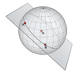
Picture for explanation - if you move/rotate the cutting plane, assuming it's clipped at O (Sol) then points A and B will be different at every single iteration.
Still, huge +rep to Mengy for research effort!
Mengy's Alien Ruins Stellar Map Theory
WOW! Worth the wait.
I too am skeptical but I really hope to be proven wrong and that it pans out.
My skepticism comes from the assumptions made. The first is that the prominent circle is the system containing the ruins - this may just as well be somewhere else (e.g. the home system of whomever created the ruins). The second is that a pyramid represents Sol - this is based on the first assumption and a measurement in metres. This could make sense if this was a human site created after the adoption of the metre (or some shoddy FDev storytelling
) but then you'd think Sol would have more prominence.My guess is you're almost correct (and by making similar assumptions), that the large "landing platform" is Sol, the pyramids are the site of outposts (the ruins) and the smaller circle is our target - a second ancient human colony - the resting place of The Missing (wild speculation klaxon). It makes more sense in a symbolic way. @Mengy - is there any chance you could use your elite CAD skills to find some candidate systems based on this? (if it makes sense to you)
Anyway, best hypothesis so far - fingers crossed!
Last edited:
Sol always stuck out to me because, to me, these ruins don't seem alien, not really anyway. It's my hunch that they were made by The Missing, humans who left Sol long ago, and maybe found something interesting, advanced, dangerous, something big enough for them to justify leaving ruins behind as a message to us as we follow in their footsteps.
Just a hunch I have, especially seeing how the map lines up with SOL as the pyramid point so precisely.
Could all be an outlandish coincidence too, I admit...
Either it's a hell of a coincidence, or you are onto something. Still, I'm a bit on the fence about the whole map thing.
I guess I'll spend some time this evening looking at the steps in details, but in any case, kudos for the work.
I really hope you cracked part of it
Some remarks about the ruins :
1) To me they do look like a forked off human culture in isolation for centuries could build. The missing ?
2) It's not too far off from sol to be the missing.
3) When flying over / driving in the ruins I get a tomb/memorial vibe.
- Status
- Thread Closed: Not open for further replies.