ED Astrometrics: Maps and Visualizations

Hi Orvidius, don't know if you can help - I lost a bunch of log files when my PC died, and we are trying to do a video of some of the commanders in the DECE expedition. I have an export from EDDiscovery, but obviously the format is very different!
Can I ask what features in the log file you are looking for to parse the jumps? I may be able to edit the file to make it look similar enough to fool the software ;)

Yep, the video creator pulls 3 log entry types: FSDJump, Location, and LoadGame (to get commander names).
 
If you have your EDD database go to a journal view, filter it to FSD Jumps, Location and Game Start events - export as raw journals and you can load it to Orvidius' tool.

I must be doing something wrong, somewhere. The EDD export doesn't quite match the ED journal file. There are extra quotes everywhere.
I tested it on EDastro, but it refused:
Warning: Unknown file type: EDDexportdata.log
No files received.

ED journal sample:
{ "timestamp":"2018-03-12T17:38:58Z", "event":"StartJump", "JumpType":"Hyperspace", "StarSystem":"Blaichuae YW-B c13-0", "SystemAddress":25803470194, "StarClass":"K" }

EDD output:
"{
""timestamp"": ""2018-03-14T21:19:24Z"",
""event"": ""FSDJump"",
""StarSystem"": ""Byua Fraae NZ-H b51-0"",
""SystemAddress"": 209245794233,
""StarPos"": [
-34399.90625,
78.84375,
47395.65625
],
""SystemAllegiance"": """",
""SystemEconomy"": ""$economy_None;"",
""SystemEconomy_Localised"": ""None"",
""SystemGovernment"": ""$government_None;"",
""SystemGovernment_Localised"": ""None"",
""SystemSecurity"": ""$GAlAXY_MAP_INFO_state_anarchy;"",
""SystemSecurity_Localised"": ""Anarchy"",
""Population"": 0,
""JumpDist"": 23.845,
""FuelUsed"": 5.371006,
""FuelLevel"": 58.628994,
""EDDMapColor"": -65536,
""EDD_EDSMFirstDiscover"": true
}"

Sorry to derail the thread!
 
The double quotes will probably mess things up. It doesn't check for that until the queue-runner starts processing though, so you won't see an error right after upload. I think I can compensate for that on my side.

The other issue is that the uploader expects the file to have the word "journal" somewhere in the file name. It's a bit of a stupid check. I might just have to remove that.

I've tweaked both of those things. Feel free to give it another shot.

EDIT: And it's not derailing the thread really. I consider this all to be part of the process. :)


It looks like there was a third commander in there, showing up as white, without the text line in the upper right. Was that the case? I may have to see what happened there.

EDIT: It looks like it's from the EDD export, and I missed one spot where I needed to add support for those double-quotes, so it was getting the events but not the commander name. I'm testing a fix now.

EDIT 2: Fix looks good, so I've deployed it, and I'm regenerating that last video of yours (same URL), so that Tazbert shows up in yellow with a proper info line. :)

EDIT 3: It's done. :)
 
Last edited:
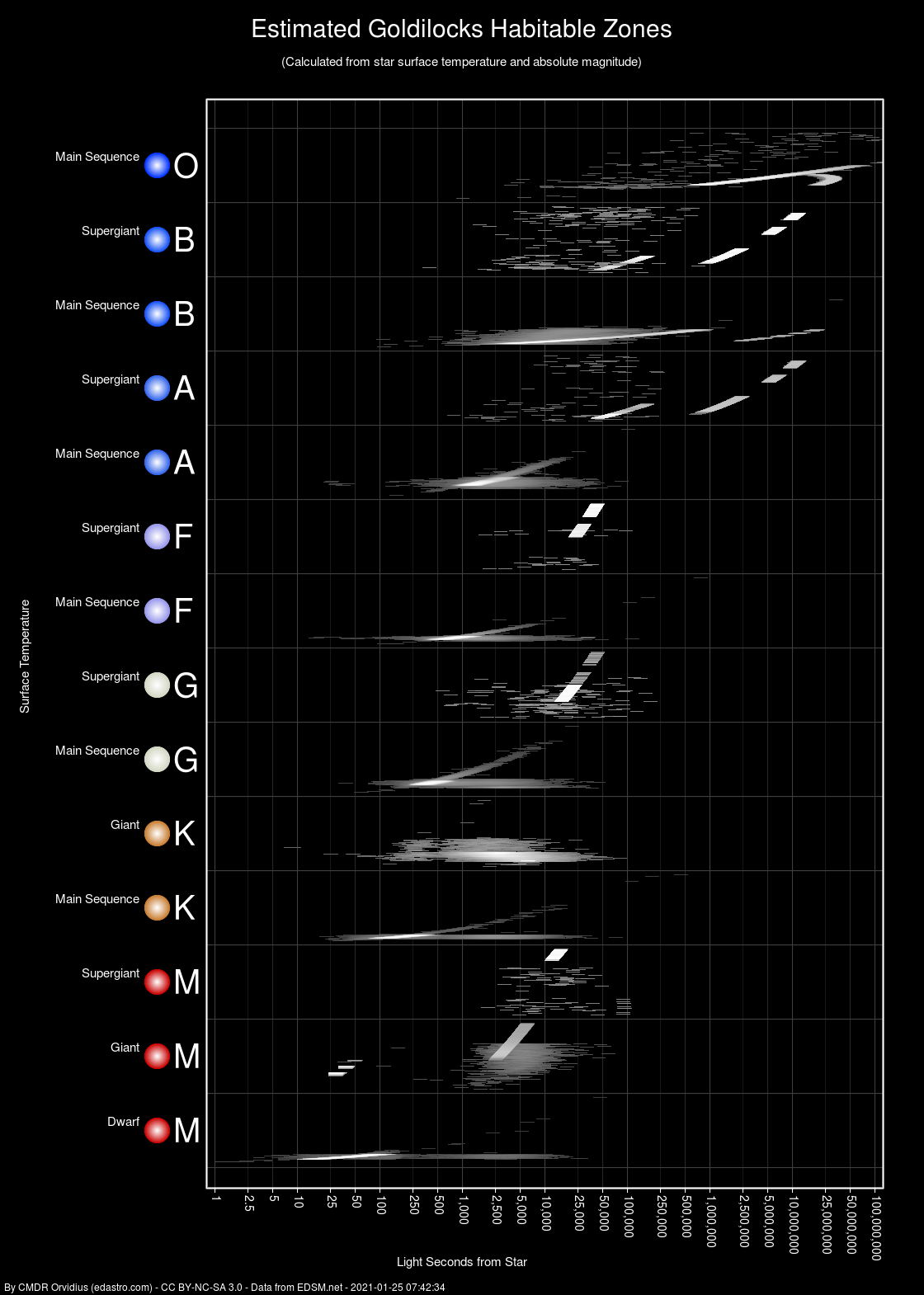
I started experimenting with habitable zones, out of pure curiosity. I found some useful calculations, and the required bolometric table (at the bottom), and decided to make a chart, shown below. It's not as useful or pretty as I had hoped, and I don't think it entirely matches what's found in game, though it's using the game's stars (absolute magnitude and surface temperature) to plot all of the range lines. I suspect now I'll need to look into pulling terraforming candidates from the EDSM data and see if I can match them to their parent stars, and plot that too, in a separate chart. (EDIT: It looks like the EDSM data dumps don't have this association)

Habitable zones:
habitablezone.png

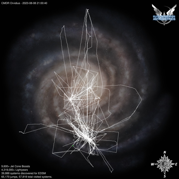
A fun little aside, on my website I added a travel history map for myself that updates nightly (actually morningly, though that's not a word). :D Since this image below is auto-updated, it'll update here in this message.

 
Last edited:
I started experimenting with habitable zones, out of pure curiosity. I found some useful calculations, and the required bolometric table (at the bottom), and decided to make a chart, shown below. It's not as useful or pretty as I had hoped, and I don't think it entirely matches what's found in game, though it's using the game's stars (absolute magnitude and surface temperature) to plot all of the range lines. I suspect now I'll need to look into pulling terraforming candidates from the EDSM data and see if I can match them to their parent stars, and plot that too, in a separate chart. (EDIT: It looks like the EDSM data dumps don't have this association)

Before EDDiscovery added the goldilocks zone I was using a updating a spreadsheet to figure out if planets were terraformable candidates. I was thinking of adding some kind of graph to visualize it better, but EDD is just too good on that.

I still use it to check secondary stars when they are far away, before trying to get there.
 
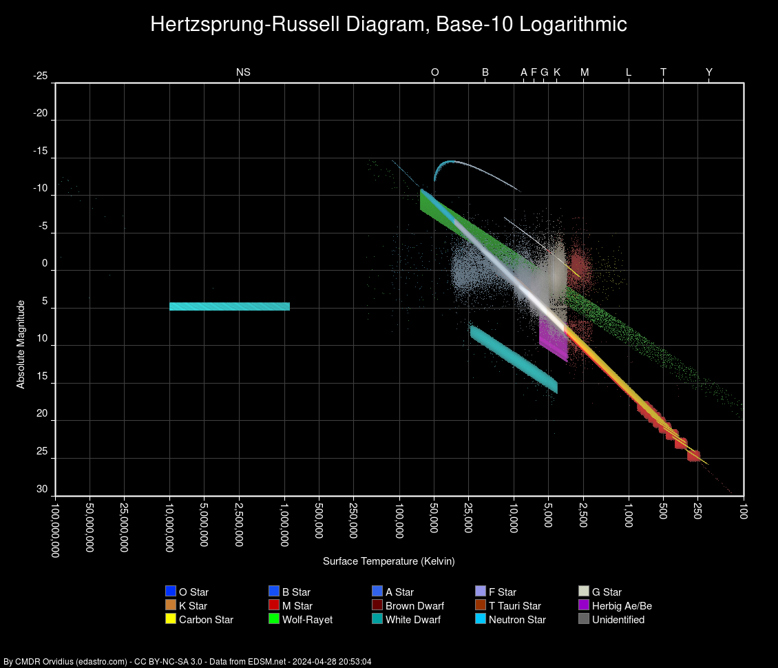
Added a stand-alone HR Diagram. For this one, I have it using a logarithmic scale for surface temperature, which nicely permits the neutron stars to be included. It also flattens the main sequence curve into a diagonal line. Historically these charts were done with linear temperature scales, but logarithmic makes more sense, and is becoming more common these days.

hr-log.png


As an aside, the neutron stars seem to go almost to 100M degrees K, in the data. I may push the scaling over a little more to accommodate those at some point. (done). The class letters along the top are just estimated positions based on some averages from real world data, rather than drawing on the game's classifications.
 
Last edited:
This game is wild. I Just have to say that I bought the gamma in Nov 2014, and once it all went live I just started exploring in my Gamma Freegle plotting star by star 10-20LY at a time. Now I see these maps and its amazing how far its all come since then.

OK /threadjack as you were.
 
Back
Top Bottom